Explore the Oregon Trail for Modern Travelers: A Complete Guide to the Historic 2,000-Mile Journey

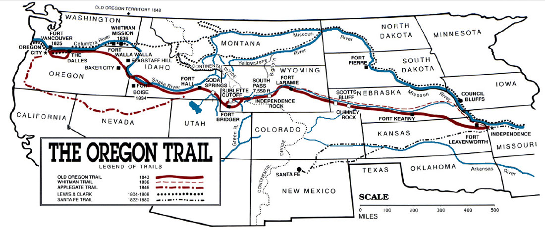
To explore the Oregon Trail for modern travelers in 2026, you should follow the Oregon National Historic Trail, a 2,000-mile route spanning six states from Missouri to Oregon. Utilizing the National Park Service’s Auto Tour Routes, travelers can visit preserved wagon ruts, historic forts, and interpretive museums while traveling via modern highways like US-26 and I-84.
The Oregon Trail remains the most iconic migration route in American history, representing the hopes, hardships, and perseverance of nearly 400,000 pioneers who trekked westward between 1836 and 1869. While the original oxen-drawn wagons are long gone, the corridor they carved across the continent is more accessible than ever. For the modern traveler, retracing this path is not merely a lesson in history; it is a profound geographic exploration of the American West, transitioning from the lush Missouri River Valley through the high desert of Wyoming and finally to the emerald forests of the Pacific Northwest.
In 2026, the experience is facilitated by a sophisticated network of state parks, federal landmarks, and local museums that ensure the story of the trail—including the perspectives of the Indigenous peoples whose lands were traversed—is told with depth and accuracy.
Understanding the Oregon National Historic Trail
The Oregon National Historic Trail is not a single, paved road, but a massive corridor of interconnected paths. Managed by the National Park Service (NPS) in collaboration with Bureau of Land Management (BLM) and various state agencies, the trail consists of "braids" where wagons fanned out to avoid the dust of those ahead of them.
For modern travelers, the journey is best approached using the Official Auto Tour Route. This route follows modern highways that closely parallel the original wagon tracks. The NPS provides detailed maps and signage—look for the iconic hexagonal trail logo featuring a covered wagon—that guide you to "high-potential" sites. These sites are designated because they offer significant historical integrity, such as visible wagon ruts (swales), original structures, or gravesites.
Planning a modern expedition requires deciding between a "completionist" approach—driving the full 2,170 miles over two weeks—or focusing on specific segments. The trail passes through Missouri, Kansas, Nebraska, Wyoming, Idaho, and Oregon. Each state offers a distinct chapter of the pioneer story, from the logistical preparations in the East to the grueling mountain passes of the West.
The Starting Line: Missouri and Kansas
Every great journey needs a "jumping-off" point, and for the 19th-century emigrants, that was often Independence, Missouri. In 2026, the National Frontier Trails Museum in Independence remains the essential first stop. Here, you can examine original diaries and artifacts that detail why families would risk everything to move west. The museum provides the necessary context for the sheer scale of the undertaking, including the cost of outfitting a wagon—roughly $800 to $1,200 in 1840s currency, which would be tens of thousands of dollars today.
As you cross into Kansas, the landscape begins to open. Modern travelers should head toward Alcove Springs near Blue Rapids. This was a favorite camping spot for pioneers due to its fresh water and lush grass. It is also a site of tragedy; it is where the ill-fated Donner Party stayed before their delayed departure led to their disaster in the Sierra Nevada. Walking the short trail to the springs, you can still see names carved into the rocks by travelers nearly 180 years ago.
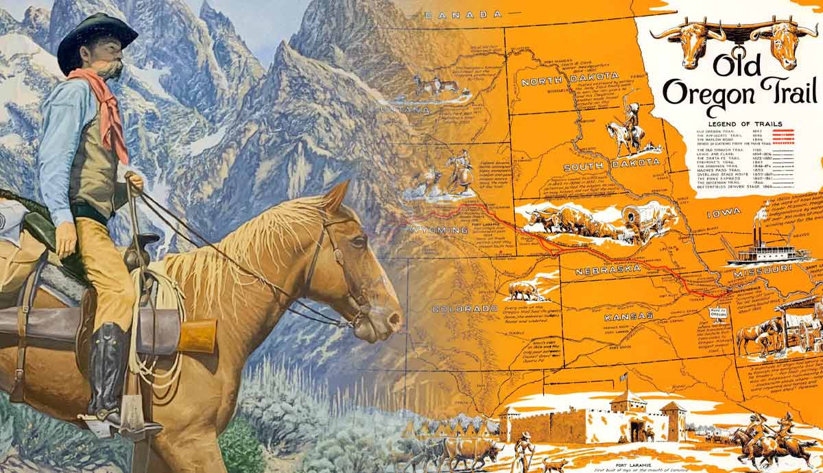
Through the Great Platte River Road: Nebraska
Nebraska contains some of the most visually stunning and well-preserved landmarks on the entire trail. The route follows the Platte River, which served as a natural highway and a vital water source.
- Fort Kearny State Historical Park: This was the first western military post established to protect the emigrants. Modern visitors can see reconstructed buildings and participate in interpretive programs that explain the role of the U.S. Army on the frontier.
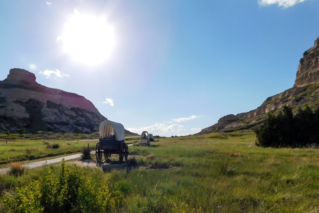
- Chimney Rock National Historic Site: Perhaps the most famous landmark on the trail, this towering spire was mentioned in more pioneer diaries than any other site. It signaled the end of the plains and the beginning of the difficult mountain terrain. The visitor center at Chimney Rock offers excellent geological and historical exhibits.
- Scotts Bluff National Monument: Rising 800 feet above the North Platte River, the bluff forced wagons into a narrow pass. Today, you can drive or hike to the summit for a panoramic view of the trail corridor. The "Legacy of the Plains Museum" nearby provides an exhaustive look at the agricultural evolution of the region.
The Nebraska segment is where modern travelers often feel the closest connection to the pioneers. The vastness of the prairie, though now punctuated by center-pivot irrigation and modern ranching, still conveys the isolation felt by those traveling at two miles per hour.
The High Desert and the Continental Divide: Wyoming
Wyoming was often the most grueling part of the journey due to the elevation gain and the lack of water. However, it also features the most spectacular physical evidence of the trail.
At Fort Laramie National Historic Site, travelers can explore a sprawling complex of restored buildings that served as a fur-trading post and later a major military installation. This was a crucial point for "re-provisioning." If a family had moved too slowly or their oxen were failing, Fort Laramie was often their last chance to adjust their loads.
Further west lies Independence Rock, a massive granite monolith known as the "Great Register of the Desert." Pioneers aimed to reach this point by July 4th to ensure they would clear the mountain passes before the winter snows. Thousands of names were carved or painted with axle grease onto the rock; many are still visible today.
The crossing of South Pass is a subtle but significant moment. Unlike the jagged peaks of the Rockies to the north or south, South Pass is a wide, gentle saddle that allowed wagons to cross the Continental Divide. For modern travelers on Highway 28, it may not look like much, but for the pioneers, it meant they had finally reached the "Oregon Country."
Into the Snake River Valley: Idaho
Idaho presented the pioneers with the treacherous Snake River. The modern traveler follows I-84 through this region, but the historical sites are tucked away along the riverbanks.
Three Island Crossing State Park in Glenns Ferry marks one of the most dangerous river crossings on the trail. Pioneers had to decide whether to risk the deep, fast-moving water to reach the better grazing on the north side or stay on the dusty, dry south bank. Every summer, the park hosts a commemoration (check current 2026 schedules for dates) that highlights the maneuvers required to get a wagon across.
Before leaving Idaho, a stop at Fort Hall (near Pocatello) is vital. While the original fort is gone, a replica in Pocatello serves as a museum. This was where the trail often split—those heading for California would turn south, while those bound for Oregon continued west.
The Final Descent: Oregon
The final leg of the journey was often the most heart-breaking. After 1,800 miles of travel, the pioneers faced the Blue Mountains and the Columbia River Gorge.
In Baker City, the National Oregon Trail Interpretive Center at Flagstaff Hill is a world-class facility. It sits on a ridge overlooking actual wagon ruts that are so deep they have never been erased by time. The center uses life-size dioramas and multimedia presentations to depict the "decision at the Dalles"—whether to float the dangerous Columbia River on a raft or take the overland Barlow Road around Mount Hood.
The trail officially ends in Oregon City at the End of the Oregon Trail Interpretive & Visitor Information Center. Marked by three giant "covered wagon" buildings, this site celebrates the arrival of the settlers. For modern travelers, it is a place to reflect on the immense distance covered and the transformation of the American landscape.
Comparing the Journey: 1840s vs. 2026
The following table highlights the radical differences between the historical trek and the modern road trip, illustrating why this remains a bucket-list journey for many.
| Feature | Pioneer Experience (c. 1848) | Modern Traveler Experience (2026) |
|---|---|---|
| Duration | 4 to 6 months | 10 to 14 days |
| Daily Distance | 10–20 miles | 200–400 miles |
| Mode of Travel | Oxen-drawn covered wagon | SUV, RV, or Electric Vehicle (EV) |
| Main Hazards | Cholera, river crossings, accidents | Traffic, weather, limited cell service in remote areas |
| Navigation | Guidebooks, landmarks, "The Trace" | GPS, NPS App, Auto Tour signage |
| Lodging | Camping under the wagon or stars | Hotels, Airbnbs, or established campgrounds |
| Primary Food | Hardtack, bacon, dried beans, coffee | Regional cuisine, grocery stores, roadside diners |
Practical Logistics for Modern Travelers
Retracing the trail in 2026 requires more than just a car and a map. To get the most out of the experience, consider these operational details:
Timing and Weather
The best time to travel is between late May and September. Early spring can bring heavy mud in Kansas and Nebraska, while late autumn may see snow in the Wyoming passes. Be aware that many smaller interpretive centers operate on seasonal schedules, often closing or reducing hours between October and April.
Connectivity and Navigation
While major highways like I-84 have excellent coverage, large sections of the trail in Wyoming and Idaho are in "dead zones." Download the National Park Service App and save the Oregon National Historic Trail maps for offline use. This app includes audio tours that trigger via GPS as you pass specific landmarks.
Vehicle Preparation
If you are driving an EV, the corridor along I-80 and I-84 is well-equipped with fast chargers. However, if you venture off-path to see remote ruts (like those at California Hill in Nebraska), ensure you have a full charge or a high-clearance vehicle for gravel roads. Always carry extra water; the high desert of Wyoming remains as arid today as it was in 1845.
Cultural Sensitivity
Modern interpretation of the trail has shifted to include the Tribal Perspectives. The trail went through the ancestral lands of the Pawnee, Sioux, Shoshone, Nez Perce, and many others. Travelers are encouraged to visit tribal cultural centers, such as the Tamástslikt Cultural Institute in Pendleton, Oregon, to understand the trail's impact on Indigenous populations and the complex legacy of westward expansion.
Frequently Asked Questions
How much does it cost to visit the main sites?
Most National Historic Sites (like Fort Laramie or Scotts Bluff) charge a nominal entrance fee, typically ranging from $10 to $20 per vehicle, or are free with an America the Beautiful Pass. State-run museums and private interpretive centers in 2026 generally cost between $5 and $15 per adult.
Can you still see actual wagon ruts?
Yes. Significant sections of "swales" (deep depressions caused by thousands of wagons) are visible at places like Guernsey Ruts in Wyoming, where the wheels carved deep grooves into soft sandstone, and at the National Oregon Trail Interpretive Center in Oregon.
Is it possible to hike the Oregon Trail?
While you cannot hike the entire 2,000 miles on a single continuous footpath (much of it is now private farmland or paved over), there are hundreds of miles of hiking trails within state and national parks that follow the exact route. The NPS website provides a list of certified hiking segments.
What is the best "hub" city for a short trip?
If you only have 3–4 days, Casper, Wyoming, is an excellent hub. It is home to the National Historic Trails Interpretive Center and is within a short drive of Independence Rock, Devil's Gate, and several well-preserved trail segments.
Is the trail suitable for families?
Absolutely. Many interpretive centers offer "Junior Ranger" programs. The mix of outdoor activity, hands-on history, and the natural "scavenger hunt" for wagon ruts makes it an engaging educational experience for children.
Final Recommendation for 2026 Travelers
To truly experience the Oregon Trail, do not rush. The pioneers were forced to observe every rock, river, and change in vegetation. While you have the luxury of speed, the greatest rewards come from stopping at the obscure roadside markers and walking the preserved swales. Start your journey by downloading the official NPS Oregon Trail Auto Tour Route guide and aim to visit at least one major interpretive center in each of the six states to grasp the full evolution of this historic trek.
Image Gallery
Select an image to open it in a new tab.





Mateo Castillo
Decentralized Finance and E-Payments Strategist
