Where Is Patagonia South America: Geographic Location, Boundaries, and Regional Overview
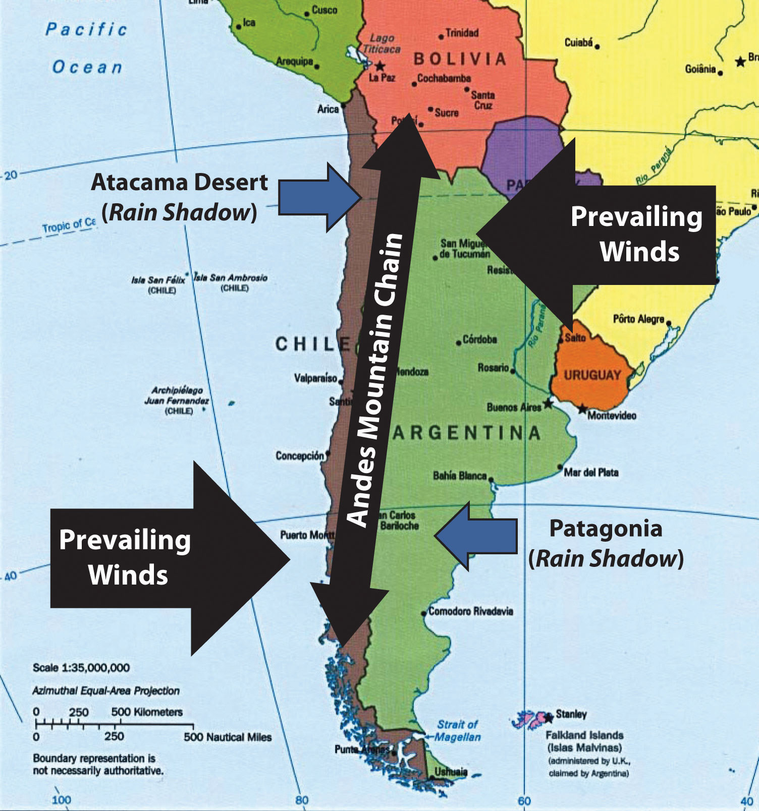
Patagonia is located at the southern tip of South America, spanning across the lower regions of both Argentina and Chile, bordered by the Pacific Ocean to the west, the Atlantic Ocean to the east, and stretching down to the subantarctic waters of Cape Horn and Antarctica.
Understanding the geographic placement of Patagonia requires looking beyond standard national borders, as this vast and dramatic territory occupies a unique transnational space. Rather than being a single country or a centralized administrative zone, Patagonia is a distinct geographical, historical, and cultural region. It encompasses sweeping steppes, massive glacial ice fields, dense temperate rainforests, and towering granite mountain spires. For travelers, geographers, and researchers alike, pinpointing its exact location involves navigating a landscape defined by extreme topography and vast distances.
Defining the Boundaries and Geographic Scope of Patagonia
Geographically, Patagonia begins roughly south of the Río Colorado in Argentina and the Río Bío Bío or Araucanía region in Chile, though definitions vary depending on cultural and political perspectives. The region stretches southward for more than a thousand miles until it terminates at the stormy confluence of the Atlantic and Pacific oceans at Tierra del Fuego and the Drake Passage.
The Andes Mountains act as a formidable natural spine running north-to-south through the center of Patagonia. This mountain range creates a stark rain shadow effect that dictates the region's climate, ecology, and human settlement patterns. To the west of the Andes lies Chilean Patagonia, characterized by a fractured coastline of fjords, channels, islands, and dense temperate rainforests. To the east lies Argentine Patagonia, dominated by expansive, windswept arid steppes, rolling plateaus, and glacial-fed rivers flowing toward the Atlantic.
The Argentine Sector of Patagonia
Argentine Patagonia covers a significantly larger land area than its Chilean counterpart and includes several distinct provinces:
- Neuquén and Río Negro: The northern gateway featuring lake districts, forests, and petroleum-rich basins.
- Chubut: Known for its Atlantic coastline, historical Welsh settlements, and the Peninsula Valdés wildlife reserve.
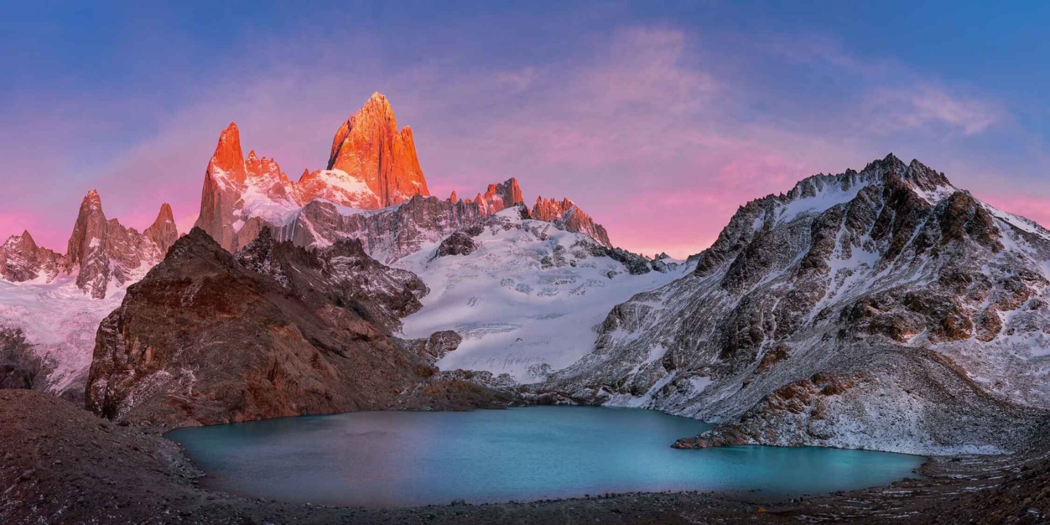
- Santa Cruz: Home to vast sheep-ranching estancias, the monumental Los Glaciares National Park, and the Fitz Roy massif.
- Tierra del Fuego (Antártida e Islas del Atlántico Sur): The southernmost province, split between Argentina and Chile, anchored by the city of Ushuaia.
The Chilean Sector of Patagonia
Chilean Patagonia is narrower due to the proximity of the Andes to the Pacific coast, yet it boasts one of the most complex shorelines on Earth. Administratively, it comprises:
- Los Lagos Region: Featuring Chiloé Island and the northern fringes of the Patagonian lake district.
- Aysén del General Carlos Ibáñez del Campo: A sparsely populated region of deep fjords, hanging glaciers, and the marble caves of Lake General Carrera.
- Magallanes y de la Antártica Chilena: The southernmost region, encompassing Torres del Paine National Park, the Strait of Magellan, and Chilean Tierra del Fuego.
Topography, Climate, and Ecological Zones
The location of Patagonia at the tail end of the South American continent exposes it to fierce meteorological forces, primarily the persistent westerly winds known as the "Roaring Forties." Because the Andes block moisture-bearing Pacific storms, the western side receives staggering amounts of rainfall, feeding massive glaciers such as the Northern and Southern Patagonian Ice Fields. Conversely, the eastern side in Argentina remains dry, cold, and windswept, creating a high-desert steppe ecosystem populated by guanacos, rheas, and hardy scrub vegetation.
| Region Characteristic | Chilean Patagonia (West) | Argentine Patagonia (East) |
|---|---|---|
| Primary Terrain | Fjords, channels, temperate rainforests, rugged Andes | Arid steppes, rolling plateaus, glacial lakes |
| Climate Influence | High maritime precipitation, mild coastal temperatures | Low precipitation, high winds, wide seasonal variations |
| Major Ecosystems | Valdivian temperate forests, subpolar marine habitats | Patagonian steppe, scrublands, freshwater biomes |
| Primary Access Routes | Carretera Austral (Chile Route 7), coastal ferries | Ruta Nacional 3 (Atlantic), Ruta Nacional 40 (Interior) |
Geopolitical Context and Administrative Divisions
Patagonia is not a sovereign state or a unified administrative territory. Instead, sovereignty is shared entirely between the nations of Argentina and Chile. This division has historical roots dating back to the colonial era and the subsequent boundary treaties signed in the late 19th and early 20th centuries, most notably the 1881 Boundary Treaty, which sought to define the border along the highest peaks of the Andes dividing the waters.
Despite international agreements, historical border disputes occasionally arose over specific ice fields and channel demarcations, though contemporary relations have established stable, peaceful borders. Travelers moving between Argentine and Chilean Patagonia must cross international borders through established mountain passes, requiring proper documentation, customs declarations, and adherence to strict agricultural biosecurity regulations designed to protect local ecosystems from invasive species and plant diseases.
Accessibility and Regional Infrastructure
Reaching Patagonia requires navigating vast distances from major international hubs such as Buenos Aires or Santiago de Chile. Due to the extreme topography, transportation networks vary significantly between the two countries.
- Air Travel: Major gateways include Bariloche, El Calafate, and Ushuaia in Argentina, as well as Puerto Montt, Balmaceda, and Punta Arenas in Chile. Regional airports connect these hubs to national capitals, though flight schedules can be heavily disrupted by sudden high winds.
- Road Networks: Ruta 40 runs parallel to the Andes down the length of Argentine Patagonia, offering paved and unpaved sections through the steppe. In Chile, the legendary Carretera Austral (Route 7) cuts through rugged wilderness, requiring a combination of driving and ferry crossings to navigate the intricate fjord systems.
- Maritime Transport: Ferries and cruise vessels provide critical links along the Chilean coast and across the Strait of Magellan, serving both commercial freight and expedition tourism.
Frequently Asked Questions
Is Patagonia a country?
No, Patagonia is not a country. It is a geographic and cultural region located at the southern tip of South America, divided politically between the nations of Argentina and Chile.
How do I get to Patagonia from North America or Europe?
Most international travelers fly into either Buenos Aires, Argentina, or Santiago, Chile, and then take a domestic connecting flight south to regional hubs like El Calafate, Bariloche, Punta Arenas, or Puerto Montt.
What is the best time of year to visit Patagonia?
The best time to visit is during the Southern Hemisphere summer, spanning from November through February. During this window, days are longer, temperatures are milder, and high-altitude hiking trails are generally free of deep snow, though high winds remain a constant factor year-round.
Which side of Patagonia is better: Argentina or Chile?
Neither side is objectively better; they offer entirely different experiences. Chilean Patagonia is celebrated for its dramatic fjords, maritime forests, and alpine trekking in parks like Torres del Paine. Argentine Patagonia is renowned for its expansive steppes, massive calving glaciers like the Perito Moreno, and the dramatic granite towers of the Fitz Roy range.
Do I need a visa to travel between Argentine and Chilean Patagonia?
Visa requirements depend on your nationality. Because a comprehensive overland itinerary often involves crossing the international border multiple times between Argentina and Chile, travelers must ensure their passports, entry stamps, and visa documentation are up to date and comply with local immigration laws.
Practical Recommendations for Visitors
When planning a journey to Patagonia, prioritize flexibility in your itinerary. Weather conditions across the southern steppes and mountain ranges change rapidly, and transport schedules can shift without warning due to wind, rain, or snow. Ensure you pack layered technical clothing, windproof and waterproof outer shells, and sturdy footwear. Always verify biosecurity rules before crossing land borders, as agricultural authorities strictly prohibit bringing fresh fruits, vegetables, and certain organic goods across the Argentina-Chile frontier.
Image Gallery
Select an image to open it in a new tab.


Celine Dubois
Contemporary Living and Global Arts Columnist
