Understanding China’s South China Sea Claims: History, Legal Framework, and Geopolitics
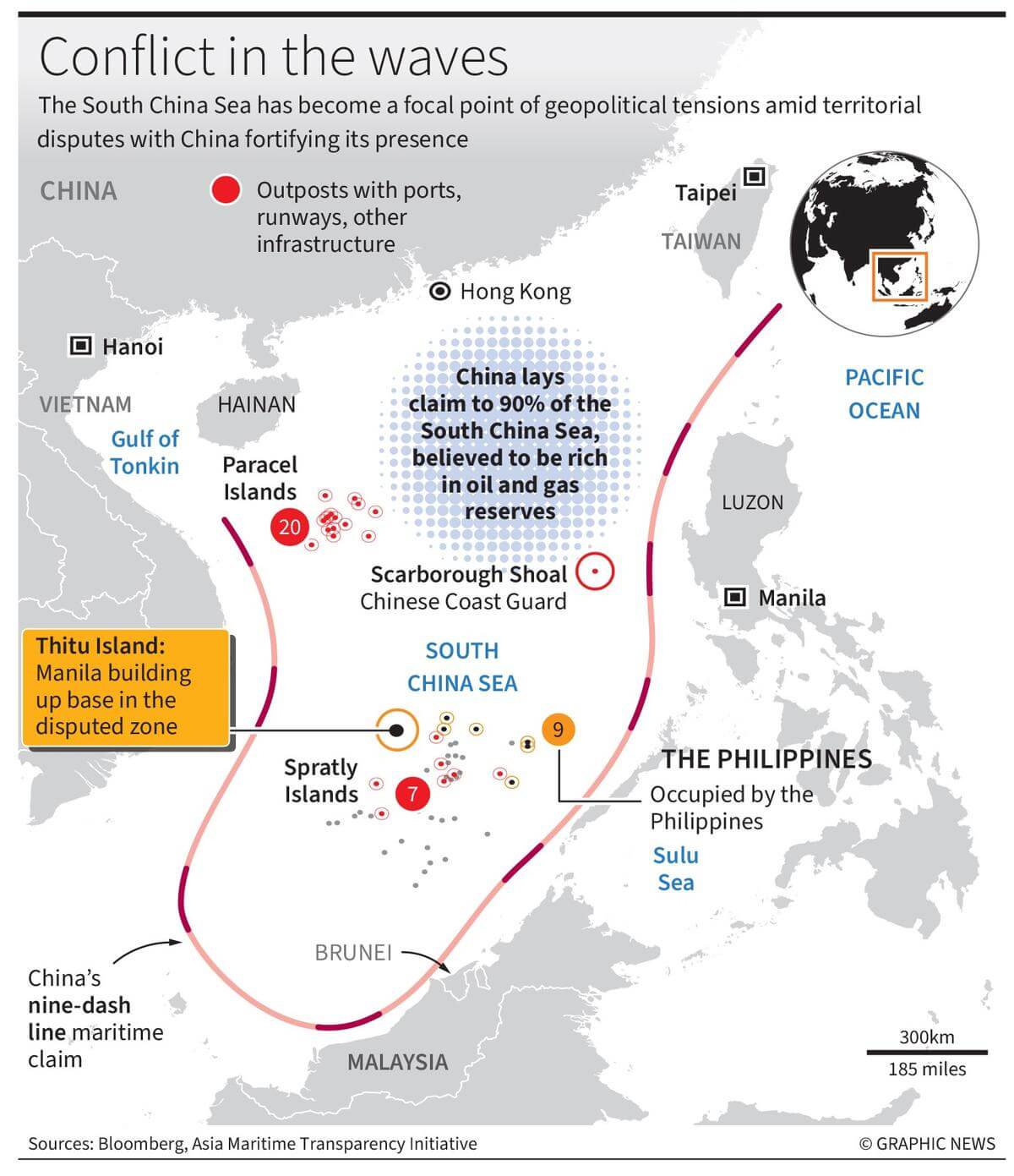
China’s South China Sea claims are anchored primarily on the controversial "nine-dash line," a demarcation encompassing the vast majority of the region’s waters, overlapping with the exclusive economic zones of several Southeast Asian nations and challenging international maritime law.
The South China Sea is one of the most vital, intensely contested, and geopolitically sensitive maritime regions in the world. At the heart of this geopolitical friction are the sweeping sovereignty and maritime rights assertions made by the People's Republic of China (PRC). Understanding what these claims entail requires an examination of historical mapping, modern international jurisprudence, strategic resource economics, and the complex diplomatic interplay between claimant states and global powers. This analysis explores the legal foundations, historical evolution, overlapping international disputes, economic stakes, and the broader implications of China's footprint in these critical waters.
Historical Evolution of the Claims and the Nine-Dash Line
To comprehend the modern architecture of China's South China Sea position, one must trace the evolution of its historical mapping. The foundational concept of China’s maritime boundary is visually represented by what is currently known as the "nine-dash line"—a U-shaped demarcation that stretches hundreds of miles south and east from the Chinese mainland, sweeping close to the coasts of the Philippines, Malaysia, Brunei, Indonesia, and Vietnam.
The origin of this boundary traces back to the mid-20th century. In 1947, the Nationalist government of the Republic of China (ROC) published a map featuring an "eleven-dash line" that claimed sovereignty over numerous island groups, shoals, and reefs within the South China Sea, including the Paracel Islands and the Spratly Islands. When the PRC was established in 1949, it generally adopted these historical maps. In the early 1950s, under the leadership of Premier Zhou Enlai, two dashes in the Gulf of Tonkin were reportedly removed, reducing the demarcation to a nine-dash line.
For decades, the legal status and precise coordinates of the nine-dash line remained ambiguous. Beijing traditionally described the line as delineating historic rights and sovereignty over the islands and adjacent waters within the boundary, yet it avoided issuing precise geographic coordinates or a definitive legal rationale under modern international law. This calculated ambiguity allowed Beijing to assert expansive jurisdiction while maintaining flexibility in diplomatic negotiations. In recent years, Chinese scholars and officials have increasingly framed these claims using terms like "four Sha" (four major island groups: the Pratas Islands, the Paracel Islands, the Macclesfield Bank, and the Spratly Islands) alongside historic rights that predate the modern United Nations Convention on the Law of the Sea (UNCLOS).
The Legal Framework: UNCLOS and the 2016 Arbitral Tribunal Ruling
The primary international legal instrument governing maritime boundaries is the United Nations Convention on the Law of the Sea, which both China and its rival claimants have signed and ratified. UNCLOS establishes a comprehensive regime of law and order in the world's oceans, establishing rules governing all uses of the oceans and their resources, including the establishment of Exclusive Economic Zones (EEZs) extending 200 nautical miles from a coastal state's baseline.
Under UNCLOS, maritime entitlements derive strictly from geographic features—such as coasts, islands, rocks, and low-tide elevations—rather than historic claims or cartographic traditions. This structural incompatibility between UNCLOS and China's historic nine-dash line set the stage for major legal confrontation.
The Philippines v. China Arbitration
In 2013, the Philippines formally initiated arbitral proceedings against China under Annex VII of UNCLOS, challenging the legality of the nine-dash line and the maritime status of various features in the South China Sea. China refused to participate in the arbitration, maintaining a position of "neither participation nor recognition," arguing that the tribunal lacked jurisdiction because the dispute fundamentally concerned territorial sovereignty and maritime delimitation, which it had excluded from compulsory dispute resolution procedures via a 2006 declaration under Article 298 of UNCLOS.
On July 12, 2016, the Permanent Court of Arbitration (PCA) in The Hague issued a landmark unanimous ruling that heavily favored the Philippines:
- The Nine-Dash Line: The tribunal ruled that any historic rights to resources within the sea areas encompassed by the nine-dash line were extinguished upon China's accession to UNCLOS, to the extent that those rights exceeded the geographic and substantive limits of maritime zones permitted by the convention.
- Status of Features: The tribunal evaluated numerous reefs, rocks, and low-tide elevations in the Spratly Islands and concluded that none of them are legally capable of generating an EEZ or a continental shelf. Features such as Mischief Reef and Subi Reef were determined to be low-tide elevations that are legally part of the Philippine seabed, not islands capable of generating territorial waters.
- Environmental and Economic Harms: The tribunal found that China's massive land reclamation and artificial island-building activities caused severe harm to the fragile marine ecosystem and that Chinese vessels had violated the traditional fishing rights of Filipino fishermen at Scarborough Shoal.
Beijing formally rejected the ruling, labeling it "null and void" and maintaining that its historical and maritime rights in the South China Sea are backed by profound historical and legal foundations.
| Feature / Concept | China's Position / Approach | International Legal Standard (UNCLOS / PCA Ruling) |
|---|---|---|
| The Boundary | Historic rights within the nine-dash (now ten-dash) line supersede modern EEZ boundaries. | Historic rights incompatible with UNCLOS; EEZ rights belong exclusively to coastal states. |
| Maritime Entitlements | Entitlements flow from island groups (four Sha) treated as single units. | Entitlements must be assessed feature-by-feature; rocks and submerged reefs generate minimal zones. |
| Island Building | Reclamation creates sovereign territory and legitimate defensive infrastructure. | Artificial islands do not alter maritime boundaries or generate new legal entitlements. |
| Dispute Resolution | Bilateral negotiations preferred; rejects third-party compulsory arbitration. | Binding arbitration permissible under UNCLOS dispute settlement mechanisms. |

Strategic Geography: Key Island Groups and Flashpoints
The South China Sea claims are physically manifested across hundreds of scattered islands, atolls, reefs, and cays. These features are grouped into distinct archipelagos, each subject to overlapping claims by different regional governments.
The Paracel Islands (Xisha Islands)
Located in the northern part of the South China Sea, the Paracels are claimed by China, Vietnam, and Taiwan. China has maintained effective control over the entire archipelago since the Battle of the Paracel Islands in 1974 against South Vietnamese forces. Over the past decade, Beijing has heavily militarized the Paracels, constructing runway facilities, harbors, and surface-to-air missile batteries on Woody Island (Yongxing Island), establishing a vital strategic hub for power projection.
The Spratly Islands (Nansha Islands)
Situated further south, the Spratlys are the most fiercely contested feature group, with partial or complete claims asserted by China, Vietnam, the Philippines, Malaysia, Brunei, and Taiwan. The geopolitical landscape of the Spratlys transformed dramatically between 2014 and 2016, when China dredged millions of tons of sand to build artificial islands on top of submerged reefs. Major outposts like Fiery Cross Reef, Mischief Reef, and Subi Reef were transformed into militarized artificial islands equipped with deep-water ports, military barracks, radar installations, and extended airstrips capable of hosting military aircraft.
Scarborough Shoal (Huangyan Dao)
Located roughly 120 nautical miles off the coast of Luzon, Scarborough Shoal is a ring of reefs and rocks claimed by the Philippines, China, and Taiwan. Following a tense maritime standoff between Chinese and Philippine vessels in 2012, China assumed de facto control of the shoal. Since then, Chinese coast guard and maritime militia ships have regularly blocked Philippine fishermen from accessing the traditional fishing grounds within the lagoon, a focal point addressed directly in the 2016 arbitral award.
Economic and Geopolitical Significance
The intensity surrounding China's maritime claims is driven by profound economic, logistical, and strategic imperatives. The South China Sea is not merely a collection of barren rocks; it is one of the world's most critical geographic arteries.
Global Trade and Maritime Commerce
An estimated one-third of all global shipping transits through the South China Sea, carrying trillions of dollars in international trade annually. For major East Asian economies—including Japan, South Korea, China, and Taiwan—the sea lanes passing through these waters represent the primary maritime highway for importing vital energy supplies, raw materials, and manufactured goods, and exporting finished products to global markets. Control over these waters translates directly into potential leverage over regional trade flows.
Natural Resources: Fisheries and Hydrocarbons
The basin is exceptionally rich in natural resources:
- Fisheries: The South China Sea accounts for roughly ten percent of the global commercial fish catch, serving as a primary source of food security and economic livelihood for millions of coastal inhabitants across Southeast Asia. Industrial fishing fleets, heavily backed by state subsidies and maritime militia vessels, frequently engage in resource competition and jurisdictional standoffs.
- Hydrocarbon Reserves: The seabed contains substantial, though frequently disputed, reserves of crude oil and natural gas. While estimates vary widely between corporate projections and government assessments, the Energy Information Administration (EIA) notes significant proved and probable reserves, particularly in contested continental shelf areas off the coasts of Vietnam, Malaysia, and Brunei.
Strategic Depth and Military Power Projection
From a national security perspective, Beijing views the South China Sea as a crucial strategic buffer. For the Chinese People's Liberation Army Navy (PLAN), securing the South China Sea provides vital bastion areas for nuclear-powered ballistic missile submarines (SSBNs) operating from naval bases on Hainan Island, ensuring a secure second-strike nuclear capability. Conversely, the United States and its allies view freedom of navigation and overflight in the region as a vital pillar of the international rules-based order, conducting regular Freedom of Navigation Operations (FONOPs) to challenge excessive maritime claims.
Regional Dynamics and International Reactions
China’s assertive posture has significantly reshaped the regional security architecture, driving shifts in diplomatic alignments and defense spending across the Indo-Pacific.
ASEAN and the Code of Conduct
The Association of Southeast Asian Nations (ASEAN) has struggled to formulate a unified response to Beijing's claims, primarily due to differing economic and diplomatic dependencies among its ten member states. While frontline claimant states like Vietnam and the Philippines frequently clash with Chinese vessels, other nations maintain closer economic ties to Beijing and resist joint communiqués that explicitly condemn Chinese actions.
Simultaneously, ASEAN and China have engaged in protracted, decades-long negotiations to establish a legally binding Code of Conduct (COC) for the South China Sea. Progress has been slow, hindered by deep disagreements over the geographic scope of the code, whether it should be legally binding, and whether it should reference international law, particularly UNCLOS.
Alignment and Defense Partnerships
The persistence of maritime disputes has catalyzed significant diplomatic recalibration. The Philippines has revitalized its security alliance with the United States, expanding access under the Enhanced Defense Cooperation Agreement (EDCA) and conducting joint maritime patrols. Furthermore, minilateral security frameworks such as the Quad (Australia, India, Japan, and the United States) and the AUKUS security pact (Australia, the United Kingdom, and the United States) emphasize maintaining a free and open Indo-Pacific, implicitly responding to the strategic challenges posed by China's maritime expansion.
Frequently Asked Questions
What is the nine-dash line?
The nine-dash line is a demarcation line historically used on Chinese maps to claim sovereignty over the vast majority of the South China Sea, including its islands, reefs, and resources. The 2016 Permanent Court of Arbitration ruled that any historic rights claimed within this boundary are incompatible with the United Nations Convention on the Law of the Sea.
Do other countries claim parts of the South China Sea?
Yes. Aside from China and Taiwan—which maintain identical historic boundary claims—several Southeast Asian nations have overlapping claims under UNCLOS. Vietnam claims the Paracels and Spratlys; the Philippines claims parts of the Spratlys and Scarborough Shoal; Malaysia and Brunei claim maritime areas and features within their respective continental shelves and EEZs.
How does UNCLOS apply to artificial islands?
Under UNCLOS, artificial islands, installations, and structures built on reefs or low-tide elevations do not possess the legal status of natural islands. They do not generate territorial waters, exclusive economic zones, or continental shelves, and their safety zones cannot exceed a 500-meter radius, regardless of military fortification.
What is the role of the maritime militia?
The maritime militia consists of commercial fishing vessels that receive state backing, funding, and tactical direction from naval or coast guard authorities. These vessels are frequently deployed to swarm contested reefs, crowd out rival fishing fleets, and assert de facto physical presence without necessarily triggering direct military conflict.
Why is the South China Sea strategically important to the United States?
The United States maintains a core national interest in ensuring freedom of navigation, unobstructed commerce, and the peaceful resolution of disputes in accordance with international law. Allowing any single nation to unilaterally control international waters or close off maritime trade routes would undermine global trade rules and freedom of the seas.
Practical Steps and Monitoring Developments
For researchers, policymakers, business analysts, and observers tracking developments in the South China Sea, relying on verified empirical data and transparent tracking tools is essential. Because rhetoric and official statements often diverge from operational realities on the water, analysts monitor developments through specific resources:
- Satellite Imagery Analysis: Organizations such as the Asia Maritime Transparency Initiative (AMTI) utilize commercial satellite imagery to track ongoing military construction, land reclamation, and the movement of coast guard and militia vessels.
- Open-Source Intelligence (OSINT): Maritime tracking platforms (such as Automatic Identification System monitoring) help identify the positioning of research vessels, oil exploration rigs, and state-backed coast guard cutters operating in contested EEZs.
- Legal Documents: Primary source documents, including official diplomatic notes verbale submitted to the United Nations Commission on the Limits of the Continental Shelf (CLCS) and the 2016 arbitral award, offer clear legal benchmarks for evaluating claims.
Understanding China’s South China Sea claims requires keeping these legal, geographical, and operational metrics in perspective as geopolitical tensions continue to shape the future of Indo-Pacific security.
Image Gallery
Select an image to open it in a new tab.
Zara El-Hashem
Sociocultural Dynamics and Academics Writer
