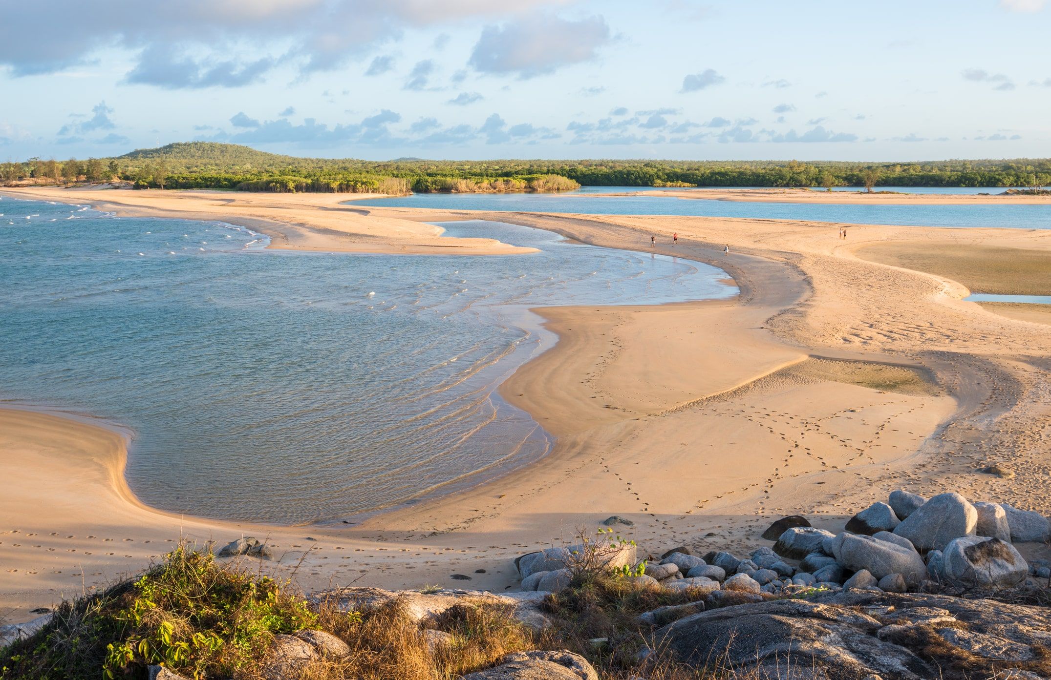
Canada holds the undisputed title of the country with the longest coastline in the world, stretching approximately 202,080 kilometers (125,567 miles). Bordered by the Atlantic, Pacific, and Arctic Oceans, its coast is characterized by a vast network of islands, deep-cut fjords, and rugged northern archipelagos that create an unparalleled geographical perimeter.
Understanding the magnitude of this coastline requires moving beyond simple linear measurements. For context, if an individual were to walk the entire length of the Canadian coast at a pace of 20 kilometers per day, it would take more than 27 years to complete the journey. However, the study of coastlines is not merely a matter of measurement; it involves complex mathematical concepts, shifting environmental factors, and significant geopolitical implications.
The Mathematical Challenge: The Coastline Paradox
To understand why Canada’s coastline is so long, one must first address the Coastline Paradox. This geographical phenomenon dictates that the length of a coastline depends entirely on the scale of the measurement tool used. Because coastlines are fractal in nature—meaning they exhibit self-similar patterns at increasingly smaller scales—the more detailed the measurement, the longer the coastline becomes.
The Richardson Effect
The paradox was famously observed by Lewis Fry Richardson and later expanded upon by Benoit Mandelbrot. If you measure the coast of Canada with a 100-kilometer ruler, you will miss thousands of small inlets, bays, and jagged rock formations. If you switch to a 1-meter ruler, you begin to account for every small cove and rocky outcrop, causing the total distance to skyrocket.
In 2026, satellite imagery and Geographic Information Systems (GIS) have reached resolutions that allow for hyper-accurate measurements. However, international bodies like the CIA World Factbook and the World Resources Institute maintain standardized datasets to allow for consistent comparison between nations. Canada’s lead is so substantial that even with varying measurement scales, it consistently remains at the top of the list.
Why Canada’s Coastline is Unrivaled
Canada’s massive coastline is a result of its unique geological history and its position across the northern reaches of the North American continent. Several specific factors contribute to this record-breaking length.
The Arctic Archipelago
The most significant contributor to Canada's coastline is the Arctic Archipelago. This region consists of 36,563 islands, including massive landmasses like Baffin Island, Victoria Island, and Ellesmere Island. The intricate channels between these islands, combined with their own jagged shorelines, add tens of thousands of kilometers to the national total.
Glacial Carving and Fjords
Much of Canada's coastline was shaped by the movement of massive ice sheets during the last glacial period. As these glaciers retreated, they carved deep, narrow valleys that were subsequently flooded by rising sea levels, creating fjords. On the Atlantic coast of Newfoundland and Labrador and the Pacific coast of British Columbia, these fjords create a "sawtooth" edge that drastically increases the surface area where land meets the sea.
The Three-Ocean Border
Canada is one of the few nations bordered by three different oceans:
- The Pacific Ocean to the west, featuring the rugged, mountainous coast of British Columbia.
- The Atlantic Ocean to the east, encompassing the maritime provinces and the jagged shores of Newfoundland.
- The Arctic Ocean to the north, which represents the largest portion of the coastline and remains ice-bound for significant portions of the year.
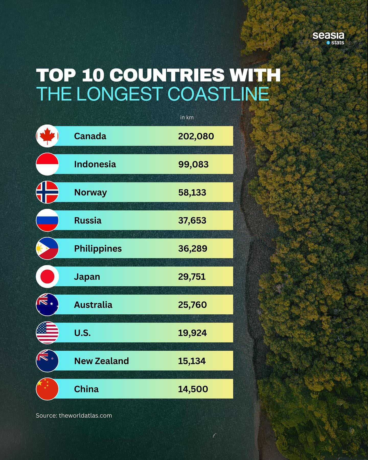
Global Comparison: Top 10 Longest Coastlines
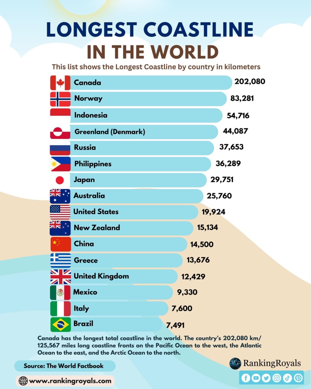
While Canada holds the top spot, other nations possess significant coastal reaches, often due to island geography or deep indentations. The following data represents the most widely accepted measurements for 2026.
| Country | Coastline Length (km) | Coastline Length (mi) | Primary Geographical Feature |
|---|---|---|---|
| Canada | 202,080 | 125,567 | Arctic Archipelago & Fjords |
| Norway | 58,133 | 36,122 | Extensive Fjord System |
| Indonesia | 54,716 | 33,999 | 17,000+ Tropical Islands |
| Russia | 37,653 | 23,396 | Vast Arctic & Pacific Borders |
| Philippines | 36,289 | 22,549 | 7,000+ Island Archipelago |
| Japan | 29,751 | 18,486 | Volcanic Island Chain |
| Australia | 25,760 | 16,007 | Massive Continental Perimeter |
| United States | 19,924 | 12,380 | Dual Ocean Border + Alaska/Hawaii |
| New Zealand | 15,134 | 9,404 | Two Major Islands & Many Minor |
| China | 14,500 | 9,010 | Eastern Continental Edge |
Note: Norway’s measurement is highly subject to the Coastline Paradox; if every small island and fjord is measured at a high resolution, some estimates place it even closer to Canada, though Canada remains the leader in almost all standardized formats.
Economic and Strategic Importance of the Coastline
A long coastline is more than just a geographic statistic; it is a vital economic and strategic asset. For Canada, this vast perimeter dictates national policy in several key areas.
Exclusive Economic Zones (EEZ)
Under the United Nations Convention on the Law of the Sea (UNCLOS), countries claim an Exclusive Economic Zone (EEZ) extending 200 nautical miles from their coast. Canada’s enormous coastline grants it one of the largest EEZs in the world, providing exclusive rights to fishing, undersea mining, and oil and gas exploration.
The Northwest Passage
As of 2026, the reduction of Arctic sea ice has made the Northwest Passage more viable for seasonal commercial shipping. This route, which threads through Canada’s Arctic islands, significantly shortens the trip between Europe and Asia. Managing this coastline is essential for Canada’s sovereignty and environmental protection in the region.
Coastal Fisheries and Biodiversity
The intersection of the Labrador Current and the Gulf Stream off the Atlantic coast creates one of the most productive fishing grounds in the world, the Grand Banks. Similarly, the Pacific coast supports vital salmon runs. Protecting these ecosystems requires massive coast guard resources due to the sheer length of the area being monitored.
Environmental Challenges Facing the World's Longest Coastline
In 2026, the Canadian coastline faces unprecedented changes driven by global climate shifts. These challenges are particularly acute in the northern regions where the majority of the coastline resides.
- Coastal Erosion: In the Arctic, the loss of permafrost—which acts as a "glue" for the soil—combined with the loss of sea ice that normally buffers waves, has led to rapid erosion. Some northern communities are being forced to relocate as the land literally disappears into the ocean.
- Sea Level Rise: While many of Canada's rocky coasts are resilient, low-lying areas in the Maritime provinces and parts of British Columbia are increasingly vulnerable to flooding and storm surges.
- Biodiversity Shifts: As ocean temperatures rise, invasive species are moving into Canadian waters, while traditional species like Atlantic cod and Pacific salmon face habitat disruption.
Technical Methods of Measuring Coastlines
To maintain the accuracy of these figures in 2026, geographers utilize a combination of traditional surveying and advanced technology.
- Satellite Altimetry: Satellites like those in the Copernicus program use radar to map the height of the sea surface and the contours of the land, helping to define the "mean high-water mark" that constitutes the baseline of a coastline.
- LiDAR (Light Detection and Ranging): Aircraft equipped with LiDAR sensors fly over coastal zones, firing laser pulses to create high-resolution 3D maps of the shore. This is essential for measuring the intricate crags of the Canadian Shield or the fjords of British Columbia.
- Bathymetric Mapping: Understanding where the land ends and the sea begins requires knowing the underwater topography. Sonar-equipped vessels map the "intertidal zone," the area between high and low tide.
Frequently Asked Questions
Why does Norway's coastline length change so much in different lists?
Norway’s coastline is uniquely complex due to tens of thousands of fjords and islands. Depending on the "ruler" used—whether a researcher includes every single indentation of a fjord or just the general perimeter—the length can vary from 25,000 km to over 58,000 km. Standardized lists usually place it second or third, but it is the primary example of the Coastline Paradox in action.
Is the United States' coastline longer than Russia's?
No. Russia has a significantly longer coastline than the United States, primarily due to its massive Arctic border. However, the United States has a very high "coastal density" regarding economic activity and population, with significant coastlines along the Atlantic, Pacific, and Gulf of Mexico, as well as the extensive shores of Alaska.
How does the length of a coastline affect a country's climate?
Countries with long coastlines often experience maritime climates, which are more temperate than continental climates. The ocean acts as a heat sink, cooling the land in the summer and warming it in the winter. In Canada, this is most evident in British Columbia and the Atlantic provinces, whereas the central provinces experience much more extreme temperature fluctuations.
Does Canada really have the most islands?
While Canada has a staggering number of islands (over 30,000 in the Arctic Archipelago alone and 30,000 in Georgian Bay), Sweden actually holds the record for the highest number of islands of any country, with over 260,000. However, Canadian islands are generally much larger, contributing more significantly to the total coastline length.
Can the length of Canada's coastline change?
Yes. Coastlines are dynamic. They change due to isostatic rebound (the land rising after the weight of ice age glaciers is removed), erosion, and sea-level rise. In the Arctic, the coastline is technically "growing" in some areas as the land rises out of the sea, while in others, it is shrinking due to rapid erosion of permafrost cliffs.
Next Steps for Exploration
For those interested in the geographical and environmental data surrounding the world's coastlines, the next logical step is to explore interactive mapping tools. Platforms such as Google Earth Engine or the National Oceanic and Atmospheric Administration (NOAA) Data Explorer allow users to visualize these coastlines at various scales, providing a first-hand look at the Coastline Paradox. Additionally, reviewing the 2026 Arctic Council reports can provide insight into how the changing coastline of Canada is affecting global trade and environmental policy.
Image Gallery
Select an image to open it in a new tab.


Declan O'Connor
Higher Education and Campus Culture Reporter
