
Hurricanes and cyclones are the same atmospheric phenomenon—tropical cyclones—but their names differ based on the storm's location. "Hurricane" is used in the North Atlantic and Northeast Pacific, while "cyclone" describes storms in the South Pacific and Indian Ocean. Both involve rotating, organized systems of clouds and thunderstorms with high-speed winds.
The Unified Science of Tropical Cyclones
To understand why different names exist for the same event, one must first understand the underlying scientific entity: the tropical cyclone. Meteorologists define a tropical cyclone as a rotating, low-pressure weather system that has organized thunderstorms but no fronts (a boundary separating two air masses of different densities). These systems derive their energy from the evaporation of warm ocean water, which re-condenses into clouds and rain, releasing latent heat in the process.
While the terminology shifts across borders, the physical structure remains identical. Every tropical cyclone, regardless of its local name, requires specific environmental conditions to form:
- Warm ocean waters: Typically at least 26.5°C (80°F) to a depth of about 50 meters.
- Atmospheric instability: An atmosphere that allows for the rapid cooling of rising air.
- Moist air: High humidity in the lower-to-mid troposphere.
- Coriolis effect: A force generated by the Earth's rotation, which is necessary to create the spin; these storms rarely form within 5 degrees of the equator.
- Low vertical wind shear: Minimal change in wind speed and direction with height, which allows the storm's structure to remain intact.
As of 2026, scientific consensus continues to emphasize that while the physics of these storms are uniform, the regional labels are deeply embedded in the administrative and cultural histories of different global basins.
Geographical Basins and Their Specific Terminology
The primary distinction between a hurricane and a cyclone is purely geographic. The World Meteorological Organization (WMO) oversees the standardization of these terms across various "basins."
The North Atlantic and Northeast Pacific: Hurricanes
In the North Atlantic, the Gulf of Mexico, the Caribbean Sea, and the Eastern and Central North Pacific (east of the International Date Line), these storms are called hurricanes. This term is derived from "Hurican," the Carib god of evil, or "Hurakan," the Mayan god of wind and storm. The National Hurricane Center (NHC) is the primary body responsible for monitoring and forecasting these events.
The Northwest Pacific: Typhoons
When the exact same type of storm occurs in the Northwest Pacific Basin (west of the International Date Line), it is referred to as a typhoon. This region is the most active tropical cyclone basin on Earth. The term "typhoon" likely originates from the Chinese "tai fung" (great wind) or the Arabic/Persian "tūfān."
The Indian Ocean and South Pacific: Cyclones
In the South Pacific and the Indian Ocean, the term used is cyclone (or more specifically, "severe tropical cyclone" or "cyclonic storm" depending on the local agency). This includes the waters around Australia, the Bay of Bengal, and the Arabian Sea. The India Meteorological Department (IMD) and the Australian Bureau of Meteorology (BOM) are key agencies in these regions.
Anatomy of a Tropical Cyclone
Whether it is called a hurricane in Florida or a cyclone in Western Australia, the internal structure of the storm follows a predictable pattern. Understanding this anatomy is crucial for interpreting weather reports and safety warnings.
The Eye
The eye is the center of the storm, characterized by relatively calm winds and clear skies. It is a roughly circular area ranging from 30 to 65 kilometers in diameter. In the eye, air sinks rather than rises, which suppresses cloud formation. Paradoxically, while the eye is the calmest part of the storm, it is surrounded by the most violent section.
The Eyewall
Surrounding the eye is the eyewall, a dense ring of towering thunderstorms. This is where the highest wind speeds are found and where the most intense precipitation occurs. When a hurricane or cyclone makes landfall, the passage of the eyewall causes the most significant structural damage.
Rainbands
Extending outward from the eyewall are curved bands of clouds and thunderstorms called rainbands. These bands can stretch for hundreds of kilometers and often contain smaller-scale tornadoes or intense bursts of wind. These bands are the first signs of an approaching storm, often arriving hours before the eye makes its way toward the coast.
Comparing Measurement Scales and Intensity
While the physical phenomenon is the same, the way we measure and categorize these storms varies significantly by region. A "Category 3" storm in the Atlantic does not necessarily mean the same thing as a "Category 3" storm in the Australian region due to different averaging periods for wind speed.
| Basin / Region | Primary Term | Intensity Scale | Wind Speed Measurement Basis |
|---|---|---|---|
| North Atlantic / NE Pacific | Hurricane | Saffir-Simpson Hurricane Wind Scale | 1-minute sustained winds |
| Northwest Pacific | Typhoon | Regional Specialized Meteorological Center (RSMC) Tokyo Scale | 10-minute sustained winds |
| Indian Ocean (North) | Cyclonic Storm | IMD Intensity Scale | 3-minute sustained winds |
| South Indian / South Pacific | Cyclone | Australian Tropical Cyclone Intensity Scale | 10-minute sustained winds |
The Saffir-Simpson Scale vs. Others
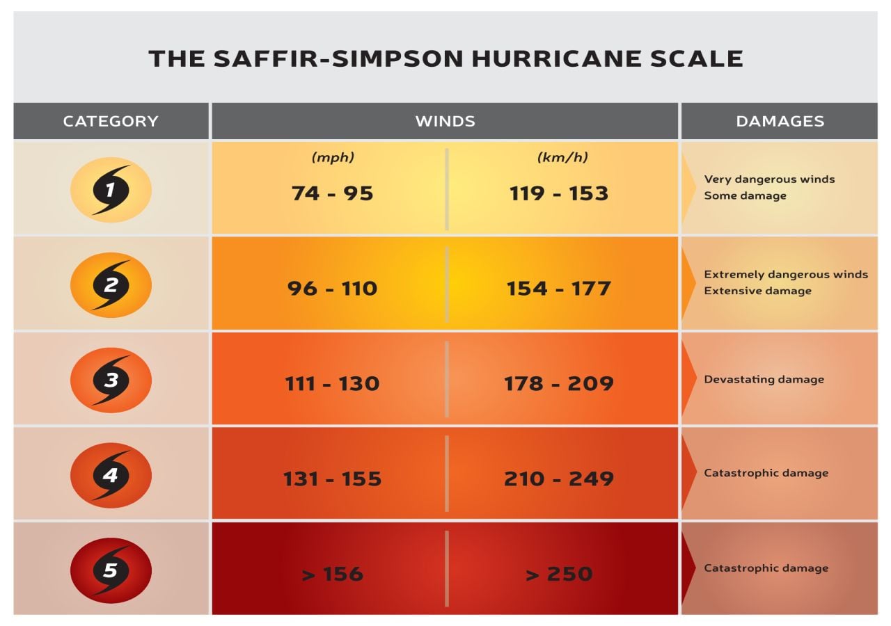
In the United States and surrounding regions, the Saffir-Simpson Hurricane Wind Scale is used, ranging from Category 1 (119–153 km/h) to Category 5 (252 km/h or higher). This scale is based solely on wind speed and does not account for storm surge or rainfall-induced flooding.
In contrast, the Australian scale used for cyclones also uses categories 1 through 5, but because it utilizes 10-minute sustained wind gusts as its metric, the thresholds for each category differ from the Saffir-Simpson scale. This often leads to confusion when international media outlets report on a storm moving from one basin to another.
The Role of the World Meteorological Organization (WMO)
The WMO acts as the coordinating body that ensures data sharing and naming consistency across different nations. Because tropical cyclones frequently cross international maritime borders, a unified approach to naming and tracking is essential for global shipping and aviation safety.
The WMO maintains revolving lists of names for each basin. These names are proposed by national meteorological services and are intended to be familiar to the people in the regions most affected. If a storm is particularly deadly or costly, its name is "retired" from the list and replaced with a new one to avoid confusion in historical records. This process is managed through regional committees, such as the RA IV Hurricane Committee for the Atlantic.
Technological Advancements in 2026 Storm Tracking
By 2026, the technology used to monitor hurricanes and cyclones has achieved unprecedented precision. The integration of AI-driven forecasting models with high-resolution satellite imagery from platforms like the GOES-R series has allowed meteorologists to predict "rapid intensification" cycles with much higher accuracy than in previous decades.
Key developments available in 2026 include:
- Uncrewed Surface Vehicles (USVs): Autonomous "saildrones" are now routinely deployed into the heart of storms to collect real-time data from the ocean-atmosphere interface, providing measurements that were previously too dangerous for human-crewed vessels to obtain.
- CubeSat Constellations: Small, low-cost satellites provide more frequent revisits over developing storms, ensuring that a hurricane's eye-wall formation is monitored almost continuously.
- Enhanced Hydrological Modeling: Modern systems now integrate wind data with topographical maps to provide hyper-local flooding forecasts, moving beyond simple "cone of uncertainty" graphics to show specific neighborhood-level risks.
These advancements help bridge the gap between regional terminologies by providing a universal set of data that all agencies, whether they call the storm a hurricane or a cyclone, can use to issue life-saving warnings.
Common Misconceptions and Clarifications
Despite the simple geographic rule, several misconceptions persist regarding these storms.
"Cyclones Rotate Differently than Hurricanes"
This is a partial truth based on hemisphere, not the name. In the Northern Hemisphere, all tropical cyclones (hurricanes, typhoons, and northern cyclones) rotate counter-clockwise due to the Coriolis effect. In the Southern Hemisphere, they rotate clockwise. Therefore, a hurricane in the Atlantic and a typhoon in the Pacific rotate the same way, while a cyclone off the coast of Fiji rotates the opposite direction.
"One is Stronger than the Other"
There is no inherent difference in strength based on the name. A "Super Typhoon" in the Western Pacific can be significantly stronger than a Category 1 hurricane in the Atlantic, but it is the environmental conditions (water temperature and wind shear), not the regional name, that dictate the storm's power. Historically, the Northwest Pacific (Typhoon basin) produces the most frequent and most intense storms due to the vast expanse of deep, warm water.
"Tornadoes and Cyclones are the Same"
This is a common error. While both involve rotating winds, tornadoes are much smaller in scale (usually less than 2 kilometers wide), form over land during severe thunderstorms, and last for minutes to hours. Tropical cyclones are hundreds of kilometers wide, form over warm oceans, and can last for weeks. However, hurricanes and cyclones can—and often do—spawn tornadoes when they make landfall.
Frequently Asked Questions
Can a hurricane turn into a typhoon?
Yes. If a hurricane in the Central Pacific crosses the International Date Line (180° West) moving westward, it is reclassified as a typhoon. Conversely, if a typhoon moves eastward across the line, it becomes a hurricane. This is a change in nomenclature only; the physical storm remains the same. A famous historical example is Hurricane/Typhoon Ioke in 2006.
Why do we name these storms?
Naming storms makes it easier for the public to track them and for emergency services to communicate warnings. Before formal naming systems were established by the WMO, storms were often identified by their latitude and longitude or the date they occurred, which was cumbersome and prone to error during rapid-fire communication.
Does climate change affect hurricanes and cyclones differently?
No, the impact is global. Research updated through 2026 indicates that while the total number of tropical cyclones may not increase significantly, the proportion of storms reaching high intensities (Category 4 and 5) is rising. Additionally, warmer atmospheres hold more moisture, leading to increased rainfall rates regardless of whether the storm is called a hurricane, typhoon, or cyclone.
What is the "Coriolis Effect" and why does it matter?
The Coriolis effect is the deflection of moving objects (like air) caused by the Earth's rotation. It is zero at the equator and increases toward the poles. Tropical cyclones require this effect to start their rotation. Because the force is too weak near the equator, hurricanes and cyclones almost never form between 5° North and 5° South latitude.
How do meteorologists decide to retire a name?
A name is retired if a storm is so devastating that the future use of its name on a different storm would be insensitive or confusing. This decision is made at the annual meetings of the WMO regional tropical cyclone committees. Once retired, the name is replaced by another of the same gender and alphabetical order.
Preparing for Tropical Storm Hazards
Regardless of whether you live in a hurricane-prone area like Florida or a cyclone-prone region like Queensland, the preparation steps are identical. The primary hazards associated with these storms—wind, storm surge, and inland flooding—require a proactive safety plan.
Immediate Actions for Residents:
- Identify Your Zone: Determine if you live in an evacuation zone. Storm surge—the rise of sea water pushed toward the shore by the force of the winds—is often the deadliest component of these storms.
- Secure Your Property: Install storm shutters or pre-cut plywood for windows. Ensure the roof is strapped to the frame of the house using "hurricane clips" or similar reinforcements.
- Create an Emergency Kit: This should include at least 72 hours of water (one gallon per person per day), non-perishable food, medications, a battery-powered radio, and portable power banks for mobile devices.
- Monitor Official Sources: Only rely on information from official government meteorological offices, such as the World Meteorological Organization's regional members. Social media can often spread unverified or outdated "spaghetti models" that can lead to dangerous decisions.
As we move through 2026, the global ability to track and understand these massive weather systems has never been better. While the names "hurricane" and "cyclone" remain divided by geography, the global effort to predict their paths and protect lives remains a unified scientific endeavor.
Image Gallery
Select an image to open it in a new tab.

Declan O'Connor
Higher Education and Campus Culture Reporter
