Exploring the Dominican Republic Terrain: A Comprehensive Guide to Geography and Adventure

Exploring the Dominican Republic terrain reveals the most topographically diverse nation in the Caribbean, characterized by five distinct mountain ranges, lush subtropical rainforests, arid desert expanses, and over 1,000 miles of coastline. From the 3,087-meter peak of Pico Duarte to the hypersaline waters of Lago Enriquillo—which sits below sea level—the country offers a complex geological tapestry for adventurers and researchers alike.
The Central Backbone: Cordillera Central and the Alpine Caribbean
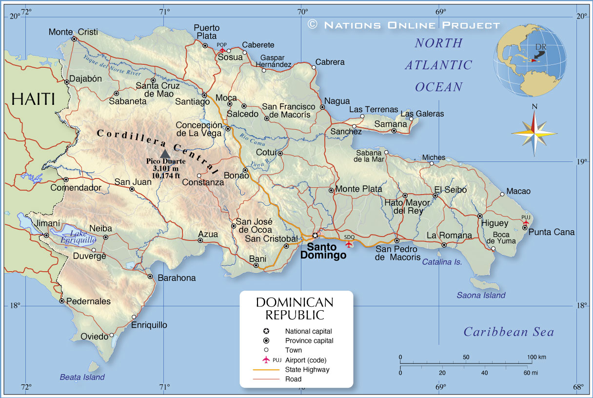
The Cordillera Central is the primary mountain range of the Dominican Republic, often referred to as the "Dominican Alps." This range is the highest in the entire Caribbean and serves as the island’s principal watershed. As of 2026, it remains the premier destination for high-altitude trekking and ecological study due to its unique microclimates and endemic species.
Pico Duarte and the High Peaks
At the heart of the Cordillera Central is Pico Duarte, standing at approximately 3,087 meters (10,128 feet). The terrain leading to the summit is a grueling mix of pine forests, rugged switchbacks, and high-altitude savannas. Exploring this terrain requires significant preparation, as temperatures at the summit can drop below freezing during the winter months, even in the tropical Caribbean. The ascent usually begins from the town of Jarabacoa or the village of La Ciénaga. The soil here is primarily acidic and nutrient-poor, supporting the Pinus occidentalis (Hispaniolan Pine), which dominates the landscape above 1,000 meters.
The Interior Valleys: Jarabacoa and Constanza
Nestled within the Cordillera Central are the high-altitude valleys of Jarabacoa and Constanza. Constanza, sitting at nearly 1,200 meters above sea level, is the highest town in the Caribbean. The terrain here is markedly different from the surrounding jagged peaks; it consists of fertile volcanic soil and a temperate climate that allows for the cultivation of strawberries, apples, and flowers—crops typically found in much cooler latitudes. This "intermontane" valley system is a geological marvel, formed by tectonic subsidence and subsequent sediment accumulation over millions of years.
Karst Formations and Coastal Cliffs: The Samaná and Los Haitises Regions
To the northeast, the terrain shifts from volcanic and metamorphic rock to dramatic limestone karst. This region, specifically the Samaná Peninsula and Los Haitises National Park, represents one of the most significant karst landscapes in the world.
The "Mogotes" of Los Haitises
Exploring the terrain of Los Haitises National Park involves navigating a labyrinth of "mogotes"—steep-sided, cone-shaped limestone hills covered in dense subtropical vegetation. These formations were created through the chemical dissolution of limestone by rainwater over eons. Below these hills lies an extensive network of marine and terrestrial caves, many of which contain Taino petroglyphs and pictographs. The terrain is notoriously difficult to traverse on foot due to the "dogtooth" limestone—sharp, jagged rock surfaces that can easily pierce standard hiking footwear.
The Samaná Peninsula
The Samaná Peninsula offers a blend of marble-rich mountains (the Sierra de Samaná) and palm-fringed coastlines. The terrain is characterized by steep ridges that drop abruptly into the Atlantic Ocean, creating secluded coves and dramatic cliffs like those found at Cabo Cabrón. In 2026, eco-tourism infrastructure in Samaná has evolved to allow for more controlled exploration of these ridges, which offer panoramic views of the whale-rich waters in the Bay of Samaná.

The Arid Southwest: Enriquillo Basin and Sierra de Bahoruco
The southwestern portion of the Dominican Republic presents a stark contrast to the lush north. This region is home to some of the most extreme terrain on the island, including the lowest point in the Caribbean.
Lago Enriquillo: Below Sea Level
The Enriquillo Basin is a rift valley that remains a remnant of an ancient marine channel. At its center lies Lago Enriquillo, a hypersaline lake situated approximately 46 meters below sea level. The terrain surrounding the lake is semi-arid to desert-like, populated by cacti, iguanas, and American crocodiles. Exploring this area requires high-clearance 4x4 vehicles, as the salt-encrusted ground and thermal heat make for a harsh environment. The lake’s water levels have historically fluctuated due to tectonic shifts and rainfall patterns, often submerging or revealing different aspects of the surrounding salt flats.
The Sierra de Bahoruco and Larimar Mines
Rising sharply from the Enriquillo Basin is the Sierra de Bahoruco. This mountain range is famous for its biological diversity and its unique mineral wealth. It is the only place in the world where Larimar, a rare blue pectolite, is mined. The terrain here is steep and often cloud-shrouded, providing a habitat for hundreds of orchid species and the rare Hispaniolan solenodon. The mining terrain itself is a network of hand-dug vertical shafts located high in the mountains, accessible only by narrow, unpaved mountain roads.
The Northern Coast: Cordillera Septentrional and the Silver Coast
The Cordillera Septentrional runs parallel to the north coast, separating the fertile Cibao Valley from the Atlantic Ocean. This range is lower than the Cordillera Central, with its highest peak, Diego de Ocampo, reaching roughly 1,249 meters.
The Cibao Valley
Often called the "food basket" of the Dominican Republic, the Cibao Valley is a vast, flat alluvial plain located between the two northern mountain ranges. The terrain is incredibly fertile, composed of deep layers of sediment washed down from the mountains. This area is the heart of the country’s tobacco and cacao production.
The Amber Coast
The northern slopes of the Cordillera Septentrional are famous for their amber deposits. Exploring this terrain involves visiting "minas de ámbar" located in the hills near Puerto Plata and Santiago. Unlike the open-pit mines found elsewhere, these are often small-scale operations where miners tunnel into the soft sedimentary rock to find fossilized resin. The coastal terrain in this region features rugged limestone terraces and golden sand beaches, shaped by the high-energy waves of the Atlantic.
Geological Origins and Tectonic Significance
The complexity of the Dominican Republic terrain is a direct result of its location at the boundary of the North American and Caribbean tectonic plates. The island of Hispaniola (shared with Haiti) was formed by the collision and accretion of several volcanic island arcs and oceanic crustal blocks.
- Plate Tectonics: The Enriquillo-Plantain Garden fault zone and the Septentrional-Oriente fault zone are the two major strike-slip faults that define the island's seismic activity and its mountain-building processes.
- Rock Composition: The island features a mix of igneous (volcanic), metamorphic, and sedimentary rocks. The presence of serpentinite and marble in the Samaná Peninsula points to deep-seated metamorphic processes.
- Elevation Diversity: The rapid rise from sea level to over 3,000 meters within a relatively small landmass is a hallmark of "active margin" geology, where tectonic forces are still actively shaping the land.
Navigating the Terrain: Practical Requirements for 2026
Exploring the Dominican Republic terrain in 2026 requires a strategic approach to logistics, gear, and timing. The country has modernized its highway system, but the most interesting terrain remains rugged and remote.
Vehicle Requirements
While a standard sedan is sufficient for travel between major cities like Santo Domingo, Puerto Plata, and Punta Cana, a 4x4 vehicle with high ground clearance is mandatory for exploring the Sierra de Bahoruco, the Enriquillo Basin, and the deep interior of the Cordillera Central. Mud-terrain tires are recommended during the rainy season (May to November) when unpaved mountain roads become slick and prone to washouts.
Seasonal Impacts
The terrain changes significantly with the seasons. The "dry season" (December to April) is the best time for high-altitude hiking, as trail conditions are stable. However, the southwest can become oppressively hot during these months. The Atlantic hurricane season (June to November) brings the risk of heavy rainfall, which can trigger landslides in the steep mountainous regions, particularly along the Cordillera Septentrional.
Essential Gear
- Footwear: For karst regions, high-durability boots with puncture-resistant soles are essential. For Pico Duarte, insulated, waterproof hiking boots are required.
- Navigation: While cellular networks are robust in 2026, GPS coverage can be spotty in deep canyons and dense rainforests. Offline topographic maps are a necessity for off-road exploration.
- Permits: Many of the most unique terrains are located within National Parks (Parques Nacionales). Entrance fees are generally modest, but some areas, like the ascent to Pico Duarte, require a certified guide and a permit from the Ministry of Environment and Natural Resources.
Comparison of Major Dominican Republic Terrains
| Region | Primary Terrain Type | Key Geological Feature | Primary Activity | Access Level |
|---|---|---|---|---|
| Cordillera Central | Alpine / High Mountain | Pico Duarte (3,087m) | Trekking / Mountaineering | Moderate (Guided) |
| Los Haitises | Limestone Karst | Mogotes and Marine Caves | Kayaking / Caving | Boat Access Only |
| Enriquillo Basin | Arid Rift Valley | Hypersaline Lake (-46m) | Wildlife / 4x4 Tours | Difficult (Extreme Heat) |
| Samaná | Rugged Coastal / Marble | Cabo Cabrón Cliffs | Hiking / Whale Watching | Moderate |
| Sierra de Bahoruco | Cloud Forest / Mineral | Larimar Mines | Mineral Tours / Birding | Difficult (4x4 Required) |
| Cibao Valley | Alluvial Plain | Fertile Farmland | Agro-tourism | Easy (Highway) |
Frequently Asked Questions
What is the most difficult terrain to explore in the Dominican Republic?
The Sierra de Bahoruco and the "dogtooth" limestone of Los Haitises are considered the most challenging. The Bahoruco range requires specialized vehicles and navigation skills due to its remoteness and steep grades. Los Haitises is physically demanding because the limestone is razor-sharp and the vegetation is exceptionally dense, making cross-country travel nearly impossible without established trails or watercraft.
Can you drive across the mountain ranges?
Yes, there are several major routes, such as the Duarte Highway (DR-1) which cuts through the mountains to connect Santo Domingo and Santiago. However, "crossing" the Cordillera Central on unpaved interior roads is a serious undertaking that requires a prepared 4x4 and should not be attempted by solo travelers unfamiliar with tropical mountain terrain.
Are there active volcanoes in the Dominican Republic?
There are no currently active volcanoes in the Dominican Republic. However, the island's terrain is largely volcanic in origin. You can find evidence of extinct volcanic activity in the form of hot springs (aguas termales) in areas like San Juan de la Maguana and through the presence of igneous rocks throughout the Cordillera Central.
How does the elevation affect the climate when exploring?
Elevation is the most significant factor in the country's microclimates. For every 1,000 meters of ascent, the temperature typically drops by about 6°C (11°F). This means that while it may be 30°C (86°F) on the coast, it could be near 12°C (54°F) in Constanza and near freezing on Pico Duarte. Travelers must pack layers even when visiting a "tropical" island.
What is the significance of the "Valle de Tetero"?
Valle de Tetero is a high-altitude savanna located in the Cordillera Central. It is significant because it represents a rare ecosystem in the Caribbean—a flat, grassy plateau surrounded by towering peaks. It is a favorite camping spot for those hiking Pico Duarte, offering a unique landscape that looks more like the Scottish Highlands than the Caribbean.
Recommendations for Future Exploration
For those planning to explore the Dominican Republic terrain in 2026, start by defining the desired experience. If you seek high-altitude adventure, base yourself in Jarabacoa and prepare for the multi-day trek to Pico Duarte. For those interested in unique geology and mineralogy, a trip to the Southwest (Barahona/Pedernales) to see the Larimar mines and Lago Enriquillo is incomparable.
Always prioritize safety by checking local weather advisories, particularly regarding rainfall in the mountains. In 2026, the Ministry of Environment offers digital permits for many national parks, which should be secured in advance. Engaging with local guides is not only a safety requirement in many areas but also provides invaluable insight into the fragile ecosystems and geological history of this diverse island nation.
Image Gallery
Select an image to open it in a new tab.



Declan O'Connor
Higher Education and Campus Culture Reporter
