
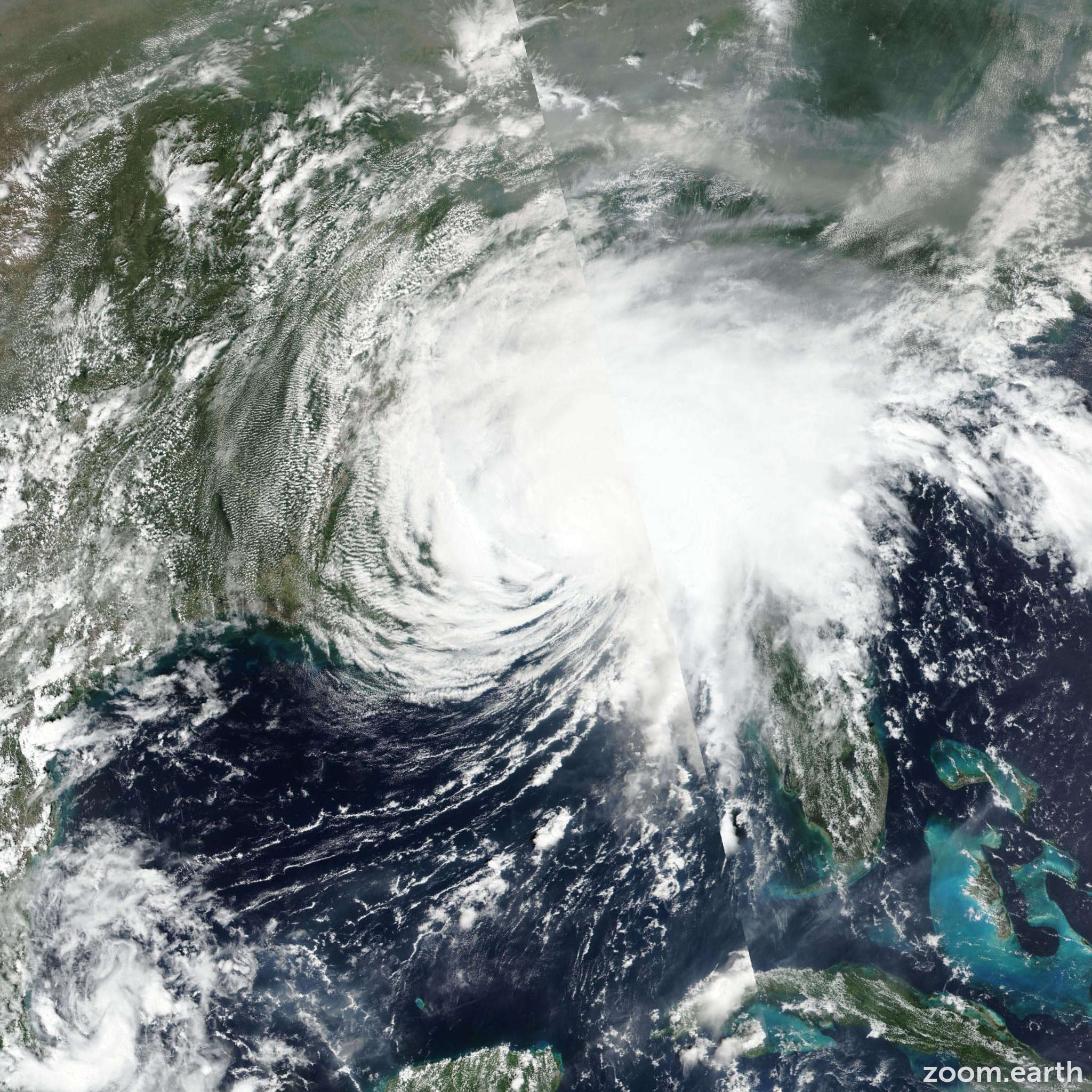
Hurricane Sally made landfall on September 16, 2020, near Gulf Shores, Alabama, as a powerful Category 2 storm. It is primarily remembered for its agonizingly slow movement and the catastrophic freshwater flooding it caused across the Florida Panhandle and southern Alabama, occurring exactly 16 years after Hurricane Ivan.
The Chronology of Hurricane Sally: From Formation to Dissipation
Hurricane Sally was a significant event within the record-breaking 2020 Atlantic hurricane season, which saw 30 named storms. Understanding the specific timing and development of Sally requires looking at the week leading up to its destructive landfall. The storm's life cycle was characterized by erratic movement and a late-stage intensification that caught some residents off guard.
Formation and Early Development (September 11–September 13)
The system that would become Hurricane Sally began as a broad area of low pressure over the Bahamas. On September 11, 2020, the National Hurricane Center (NHC) designated the system as Tropical Depression Nineteen. It moved across the Florida Everglades and into the eastern Gulf of Mexico as a disorganized system.
By September 12, the system strengthened into Tropical Storm Sally. During this early phase, its primary impact was heavy rainfall across South Florida and the Keys, which served as a precursor to the massive precipitation totals it would eventually dump on the Gulf Coast.
Strengthening in the Gulf (September 14–September 15)
As Sally moved into the warm waters of the Gulf of Mexico, it began a period of intensification. On September 14, it was upgraded to a Category 1 hurricane. Meteorologists initially struggled with the forecast because the steering currents—the high-altitude winds that move a storm along—were exceptionally weak. This caused Sally to slow to a crawl, moving at just 2 to 5 miles per hour.
During the late hours of September 15 and the early morning of September 16, Sally underwent a final burst of intensification. Despite facing wind shear, it reached Category 2 status with maximum sustained winds of 105 mph shortly before reaching the coastline.
Landfall and Post-Tropical Transition (September 16–September 18)
Hurricane Sally officially made landfall at approximately 4:45 AM CDT on September 16, 2020. The center of the eye crossed the coast near Gulf Shores, Alabama. Because the storm was moving so slowly—comparable to a person’s walking pace—the eyewall battered the same locations for several hours.
After landfall, Sally weakened as it moved northeast across Alabama and Georgia. It was downgraded to a tropical depression on September 17 and eventually became a post-tropical remnant low as it moved off the coast of the Carolinas into the Atlantic on September 18, 2020.
Meteorological Characteristics: Why Sally Was Unique
Hurricane Sally was not a "typical" Category 2 storm. While its wind speeds were significant, the primary driver of its $7.3 billion in damages was its lack of forward momentum. To understand the severity of the event, one must look at the meteorological factors that allowed it to stall.
The Stall and the "Firehose" Effect
In tropical meteorology, the damage potential of a storm is often a function of its speed. While a fast-moving Category 4 storm might cause massive wind damage, a slow-moving Category 2 storm like Sally can be more devastating due to rainfall duration. Sally’s forward speed dropped to nearly 2 mph near landfall. This created what meteorologists call a "firehose effect," where a stationary band of intense rain sits over the same geographic area for 24 to 48 hours.
Record-Breaking Precipitation
Some areas in Northwest Florida and South Alabama received upwards of 30 inches of rain. Bellview, Florida, recorded a staggering 30.00 inches, while parts of Pensacola saw nearly 25 inches. This volume of water overwhelmed drainage systems and caused rivers like the Perdido and the Shoal to reach record or near-record crests.
The Anniversary Connection
A notable coincidence in meteorological history is that Hurricane Sally made landfall on the same day—and in almost the same location—as Hurricane Ivan in 2004. Both storms struck on September 16. While Ivan was a much larger and stronger storm (Category 3 at landfall), Sally’s flooding in certain areas surpassed that of Ivan due to the difference in rainfall totals.

Impact Analysis: Damage to Infrastructure and Environment
The damage from Hurricane Sally was widespread, affecting everything from residential housing to major transportation infrastructure. Now, in 2026, the long-term recovery efforts have mostly concluded, but the lessons learned regarding building codes and bridge safety remain central to Gulf Coast urban planning.
The Pensacola Bay Bridge Incident
One of the most publicized impacts of Hurricane Sally involved the Pensacola Bay Bridge (also known as the "Three Mile Bridge"). During the storm, several construction barges owned by Skanska USA broke loose from their moorings. These barges collided with the newly constructed bridge, causing significant structural damage and forcing the closure of this vital artery between Pensacola and Gulf Breeze for several months. This event highlighted the risks associated with large-scale maritime construction during hurricane season.
Coastal Erosion and Storm Surge
While rainfall was the primary story, Sally also produced a significant storm surge. In Dauphin Island, Alabama, and across the Florida Panhandle, surge levels reached 5 to 6 feet. This surge, combined with high wave action from the slow-moving storm, caused severe coastal erosion and damaged hundreds of piers and boat houses. In some areas, the surge pushed sand several blocks inland, burying roads and first floors of coastal properties.
Agricultural and Forestry Losses
Further inland, Sally’s winds and rain took a toll on the agricultural sector. In Alabama and Georgia, the storm struck during the peak of the cotton and peanut harvest seasons. The heavy saturation of the soil caused "lodging," where crops are blown flat against the ground, making them impossible to harvest. Additionally, the timber industry suffered losses as saturated ground allowed winds to easily topple pine and hardwood trees.
Hurricane Sally Statistical Overview
The following table summarizes the key metrics of Hurricane Sally as documented by the National Hurricane Center.
| Metric | Details |
|---|---|
| Peak Intensity | Category 2 (Saffir-Simpson Scale) |
| Maximum Sustained Winds | 105 mph (165 km/h) |
| Minimum Central Pressure | 965 mbar (hPa) |
| Landfall Date & Time | September 16, 2020, 4:45 AM CDT |
| Landfall Location | Gulf Shores, Alabama |
| Highest Rainfall Total | 30.00 inches (Bellview, FL) |
| Estimated Damage | ~$7.3 Billion (2020 USD) |
| Fatalities | 9 (Direct and Indirect) |
The Retirement of the Name "Sally"
Due to the extensive damage and the unique challenges the storm presented to the Gulf Coast, the name "Sally" was officially retired by the World Meteorological Organization (WMO) in March 2021. In the six-year rotation of Atlantic hurricane names, the 2020 list was scheduled to reappear in 2026. However, because the name was retired, it has been replaced.
Starting in the 2026 hurricane season, the name Stella will be used in place of Sally. The retirement of a name is a significant event, reserved for storms that are particularly lethal or costly, ensuring that the name "Sally" remains historically linked only to the 2020 event.
Preparation and Safety: Lessons from 2020
Hurricane Sally serves as a critical case study for emergency management. It proved that a storm’s category—which only measures wind speed—does not always tell the full story of its danger.
- Water Over Wind: Sally reinforced the fact that water (storm surge and inland flooding) is responsible for the vast majority of tropical cyclone fatalities and damage. Residents are now encouraged to look at rainfall forecasts and "flooding potential" maps just as closely as the "cone of uncertainty."
- The Danger of "Slow" Storms: A weakening storm that is slowing down can often be more dangerous than a strengthening storm that is moving quickly. The duration of stress on structures and the accumulation of rainfall are force multipliers for damage.
- Bridge and Barge Safety: The Pensacola Bay Bridge incident led to stricter regulations regarding how maritime equipment and construction materials must be secured when a tropical system enters the Gulf of Mexico, even if a direct hit is not initially forecast.
Frequently Asked Questions
What day did Hurricane Sally hit?
Hurricane Sally made its primary landfall on Wednesday, September 16, 2020. The storm reached the coast in the early morning hours, around 4:45 AM CDT. However, the outer bands began affecting the Florida and Alabama coastlines as early as September 14, providing a prolonged period of wind and rain.
Where exactly did Hurricane Sally make landfall?
The center of Hurricane Sally’s eye moved ashore near Gulf Shores, Alabama. Because the eyewall was quite large and the storm moved slowly, the impacts were felt intensely from Mobile Bay in Alabama all the way to Navarre Beach in Florida.
How much rain did Hurricane Sally produce?
Sally produced historic rainfall totals, peaking at 30 inches in Bellview, Florida. Most of the Alabama-Florida border region received between 15 and 25 inches of rain. This caused "500-year" flood events in several river basins throughout the region.
Was Hurricane Sally worse than Hurricane Ivan?
The comparison depends on the type of damage. Hurricane Ivan (2004) was a stronger storm in terms of wind speed and surge height, causing more widespread structural destruction from wind. However, Hurricane Sally (2020) caused more severe freshwater flooding in many areas due to its slower movement and higher rainfall totals. Both struck on the same calendar day, 16 years apart.
What is the 2026 replacement name for Sally?
The name "Sally" was retired following the 2020 season. For the 2026 Atlantic hurricane season, the name Stella has been added to the list to replace it. This is part of the standard WMO procedure to avoid confusion and show respect for the victims of severe storms.
Next Steps for Residents
If you live in a hurricane-prone area, the history of Hurricane Sally should serve as a reminder to review your flood insurance policies. Many homeowners discovered during Sally that their standard homeowner’s insurance did not cover the rising groundwater and "freshwater" flooding caused by the storm's intense rain.
As we progress through the 2026 season, ensure your emergency kit includes at least three days of water and non-perishable food, and always pay attention to "flash flood" warnings, even if a hurricane is only rated as a Category 1 or 2.
Image Gallery
Select an image to open it in a new tab.



Akira Tanaka
International Academic Trends Correspondent
