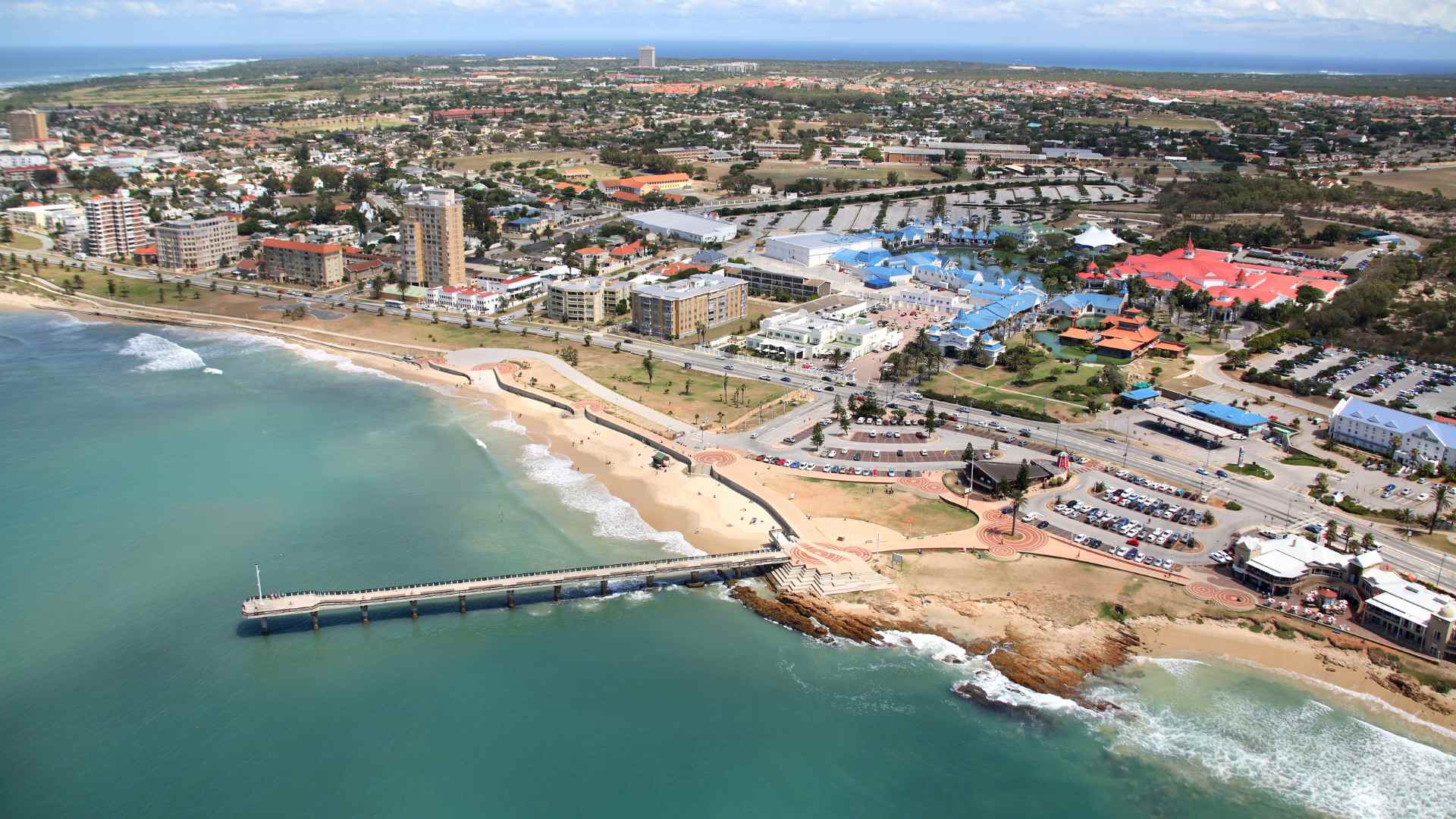
Port Elizabeth, officially known as Gqeberha, experiences a maritime climate defined by consistent wind patterns and significant wave energy moderated by the protective curve of Algoa Bay. Dominant winds alternate between the powerful South-Westerly "Busters" and the persistent Summer South-Easterlies, while wave conditions are governed by Southern Ocean swells that refract around Cape Recife, creating a unique environment for maritime commerce and coastal recreation.
The Geographic Context of Algoa Bay
To understand the wind and waves at Port Elizabeth, one must first look at the unique bathymetry and coastal orientation of Algoa Bay. Located on the southeastern coast of South Africa, the city sits on the western edge of a wide, east-facing bay. This orientation is the single most important factor in determining how the city interacts with the elements.
The bay is anchored by Cape Recife to the south and Woody Cape to the northeast. Cape Recife acts as a massive natural breakwater. For centuries, this headland has protected the inner reaches of the bay from the full, unbridled force of the Southern Ocean's swells. However, this protection is selective; while it blocks the direct impact of South-Westerly swells, it allows for complex wave refraction and diffraction, which determines the specific surf and harbor conditions found at the Port Elizabeth beachfront.
The continental shelf in this region is relatively narrow compared to other global shorelines but wide enough to influence wave steepness as energy moves from the deep Agulhas Current regions into the shallower coastal waters. As of 2026, coastal monitoring stations indicate that the underwater topography continues to shift slightly due to sediment transport, influencing localized "sand-slug" movements that can alter wave breaks at popular spots like Pollock Beach.
The Wind Regimes of the "Windy City"
Port Elizabeth has long held the moniker of the "Windy City." While meteorological data often shows that other South African cities, such as Cape Town, may experience higher peak gusts during specific seasons, Port Elizabeth is characterized by the sheer frequency and consistency of its wind. There are very few days in a calendar year where the air is truly still.
The South-Westerly Wind (The "Buster")
The South-Westerly is the most frequent wind direction in Port Elizabeth, particularly dominant during the winter months (June through August). These winds are typically associated with the passage of cold fronts moving from west to east across the Southern Ocean.
When a cold front approaches, the wind often begins as a "Berghwind"—a hot, dry wind blowing from the interior mountains toward the coast. As the front passes, the wind "swings" violently to the South-West. These "Busters" can reach speeds exceeding 80 km/h (approx. 43 knots) within minutes. In 2026, these events remain the primary concern for the Port of Ngqura and the Port of Port Elizabeth, as they can necessitate the cessation of crane operations to ensure safety.
The South-Easterly Wind
Dominant during the summer months (November through February), the South-Easterly is driven by the South Atlantic High-Pressure system ridging south of the continent. Unlike the gusty South-Westerly, the South-Easterly tends to be more persistent and consistent.
While it provides a cooling effect during the humid summer months, the South-Easterly is responsible for creating "choppy" sea conditions within Algoa Bay. Because the wind blows across the open expanse of the Indian Ocean, it has a significant "fetch" (the distance over which wind blows without obstruction), allowing it to generate short-period, localized wind waves that can make sailing and boat angling challenging.

Wave Mechanics: Swell Entry and Refraction
The waves reaching the shores of Port Elizabeth are primarily generated thousands of kilometers away in the Roaring Forties of the Southern Ocean. These are "long-period" swells, often characterized by periods of 10 to 16 seconds.
The Role of Cape Recife
As these massive swells travel northeast, they encounter Cape Recife. Because waves slow down in shallower water, the portion of the wave closest to the Cape slows first, causing the wave crest to "bend" or refract around the point. This refraction process filters the energy. By the time the swell reaches the main city beaches (such as King's Beach or Humewood), it has lost much of its raw height but gained organization and "cleanliness."
This is why Port Elizabeth is famous for its "long-period" right-hand point breaks. The waves wrap around the coastline, following the contours of the bay. Without the presence of Cape Recife, the Port Elizabeth beachfront would be an extremely high-energy environment, likely unsuitable for the existing port infrastructure.
Wave Heights and Energy
Average offshore wave heights near the mouth of Algoa Bay typically range between 2 and 4 meters. However, during significant winter storms, offshore heights can exceed 8 meters. Due to the sheltering effect described above, the "inshore" wave height at the city’s swimming beaches is usually significantly lower, often averaging between 0.5 and 1.2 meters.
| Season | Primary Wind | Avg. Wind Speed | Avg. Wave Height (Inshore) | Primary Swell Direction |
|---|---|---|---|---|
| Summer | South-East | 20–35 km/h | 0.8m – 1.5m | South-East / East |
| Autumn | Variable | 15–25 km/h | 1.0m – 1.8m | South-West (Refracted) |
| Winter | South-West | 30–60 km/h | 1.5m – 2.5m | South-West |
| Spring | Variable / SW | 25–45 km/h | 1.2m – 2.0m | South-West / South |
Impact on Maritime and Port Operations
Port Elizabeth is unique in that it hosts two major commercial ports: the Port of Port Elizabeth (the "City Port") and the Port of Ngqura (located roughly 20km to the northeast). Both are deeply affected by the interplay of wind and waves.
Port of Port Elizabeth
The older city port is highly protected by a massive breakwater. However, it is susceptible to "surging." Surging occurs when long-period swells create low-frequency oscillations within the harbor basin. This can cause moored ships to move significantly, straining lines and occasionally interrupting the loading of bulk cargo. The "Windy City" factor also plays a role; high-sided car carriers (Port Elizabeth is a major automotive hub) act as giant sails, making docking maneuvers during South-Westerly gales extremely technical for harbor pilots.
Port of Ngqura (Coega)
The Port of Ngqura was designed as a deep-water port to handle the world's largest container vessels. Because it is positioned further east and is less protected by Cape Recife than the city port, it is more exposed to South-Easterly swells. In 2026, advanced berth monitoring systems are used to predict "long-wave" activity that could affect vessel stability. The primary operational constraint here is wind; when wind speeds exceed specific safety thresholds (usually around 60-70 km/h), the massive ship-to-shore gantry cranes must be locked down to prevent structural damage.
Recreational Implications: Surfing, Sailing, and Diving
For the residents and tourists of 2026, the wind and waves are more than just meteorological data; they are the framework for lifestyle.
Surfing and Water Sports
The "Bay" is a world-class destination for various water sports.
- Surfing: The most famous break is "The Pipe" at Pollock Beach. It relies on a South-Westerly swell refracting around Cape Recife, met with a light South-Westerly or North-Westerly offshore wind to groom the wave faces.
- Kiteboarding and Windsurfing: The South-Easterly summer winds provide "side-onshore" conditions that are ideal for kiteboarding, particularly at beaches like Noordhoek (on the "Wildside") or Bluewater Bay.
- Sailing: Algoa Bay is regarded as one of the best sailing venues in the southern hemisphere due to its consistent winds and relatively low current. The Algoa Bay Yacht Club frequently hosts national and international regattas.
Diving and Visibility
The waves and wind also dictate underwater conditions. A strong South-Easterly wind often leads to "upwelling." This occurs when surface water is pushed away from the coast, allowing colder, nutrient-rich water to rise from the depths. While this can drastically drop the water temperature (sometimes from 21°C down to 14°C in 24 hours), it often brings exceptional clarity, making it the preferred time for scuba diving on the many shipwrecks and reefs scattered throughout the bay.
Technical Monitoring and Forecasting in 2026
Accurate forecasting is essential for safety in Port Elizabeth. Several organizations provide the technical infrastructure required to monitor these conditions:
- The South African Weather Service (SAWS): Operates the primary coastal weather stations and provides official gale-force wind warnings. SAWS Official Website
- CSIR (Council for Scientific and Industrial Research): Maintains a network of "Wave Rider" buoys. These buoys measure significant wave height, peak period, and direction in real-time. This data is critical for port engineers and marine scientists.
- Transnet National Ports Authority (TNPA): Utilizes localized anemometers and tide gauges to manage vessel traffic within the two ports.
For surfers and sailors, digital tools like specialized swell models have become highly localized. In 2026, these models account for the "Cape Recife shadow," a phenomenon where a few degrees of swell direction change can mean the difference between massive waves at the "Wildside" and a completely flat sea at the city beachfront.
Safety and Environmental Considerations
The power of the wind and waves at Port Elizabeth carries inherent risks. The "Wildside"—the stretch of coast south of Cape Recife—is significantly more dangerous than the bay beaches. Here, the coast is exposed to the full force of the Indian Ocean. Rip currents are powerful and ubiquitous, and the wind is often significantly stronger than it is just five kilometers away inside the bay.
Coastal erosion is a continuing challenge. The combination of high-spring tides and large storm swells (frequently occurring in the transition months of March and September) can lead to significant "scouring" of the beaches. Local government initiatives in 2026 continue to focus on maintaining the dune systems at places like Summerstrand, which serve as the final line of defense against wave-driven erosion.
FAQ: Wind and Waves at Port Elizabeth
What is the best time of year for surfing in Port Elizabeth? The winter months (June to August) are generally considered the best. This period coincides with the most frequent and powerful South-Westerly swells generated by Southern Ocean storms. These swells wrap perfectly into the bay, providing consistent, clean waves at the city's main breaks.
Is it always windy in Port Elizabeth? While it is not literally "always" windy, the city has one of the highest percentages of "windy days" in South Africa. Calm days (less than 5 knots) are rare and usually occur during the transition between weather systems in Autumn or Spring.
Why is the water sometimes very cold in summer? This is due to "upwelling" caused by the South-Easterly wind. This wind pushes the warm surface water out to sea, and to replace it, cold water is drawn up from the deep ocean. It is common for water temperatures to drop 5-7 degrees Celsius within a single day of strong South-Easterly winds.
How do wind conditions affect the Port of Ngqura compared to the Port of Port Elizabeth? The Port of Ngqura is more exposed to the "fetch" of the South-Easterly wind, which can create larger swells at the harbor entrance. However, both ports are primarily restricted by wind speeds that affect crane operations. Because Ngqura is further from the sheltering hills of the city center, it often records slightly higher average wind speeds than the Port Elizabeth city port.
Are the waves in Port Elizabeth safe for swimming? The main city beaches (King's Beach, Humewood, and Hobie Beach) are generally very safe because they are protected by Cape Recife. This protection filters out the dangerous energy of the Southern Ocean swells. However, swimmers should always stay within designated areas marked by lifeguards, as rip currents can still form, especially near the piers.
Practical Recommendations for Visitors and Professionals
Whether you are a maritime professional or a recreational visitor, navigating the wind and waves of Port Elizabeth requires a "direction-first" mindset. Always check the forecasted wind direction before planning activities.
If the forecast calls for a South-Easter, the bay will be choppy, the water may become cold due to upwelling, and the "Wildside" beaches (like Sardinia Bay) will be offshore and beautiful but potentially dangerous for swimming.
If the forecast calls for a South-Wester, expect a drop in temperature and potentially rain. This is the time for experienced surfers to head to the point breaks, but sailors should be cautious of the "Buster" gusts that can exceed predicted averages. For the most accurate real-time data in 2026, always cross-reference the SAWS maritime updates with local buoy data from the CSIR to ensure a complete picture of the current sea state.
Image Gallery
Select an image to open it in a new tab.

Declan O'Connor
Higher Education and Campus Culture Reporter
