What the Pacific Ring of Fire Means: A Comprehensive Guide to Earth’s Most Active Zone
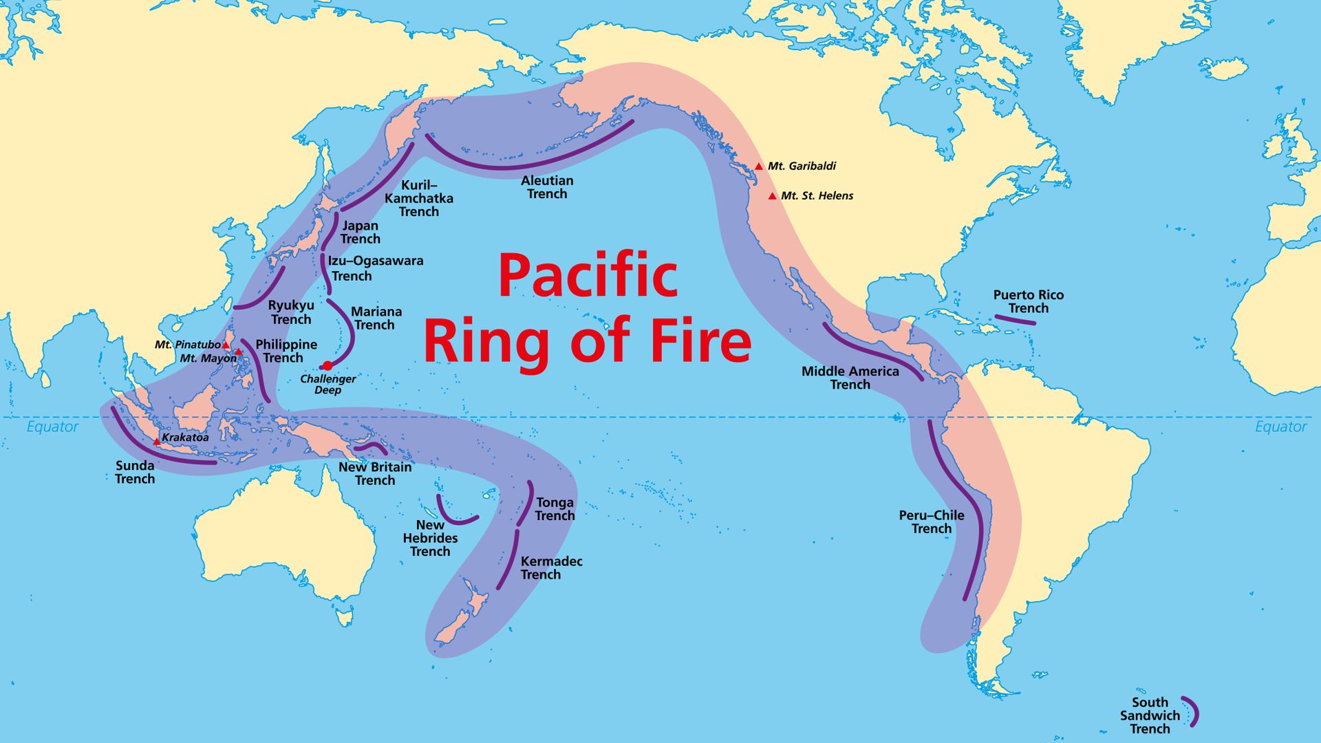
The Pacific Ring of Fire is a 40,000-kilometer (25,000-mile) horseshoe-shaped region characterized by intense volcanic activity and frequent earthquakes. It signifies the boundaries of several tectonic plates, where subduction and movement create 75% of the world's active volcanoes and 90% of its seismic events, shaping the geography and safety of surrounding nations.
Understanding the Fundamental Tectonic Mechanics
To understand what the Pacific Ring of Fire means from a geological perspective, one must first grasp the concept of plate tectonics. The Earth’s outer shell, or lithosphere, is not a solid piece but a series of massive, rigid plates that "float" on the semi-liquid asthenosphere beneath them. The Ring of Fire is essentially a visual and physical map of where the Pacific Plate interacts with its neighbors.
The primary driver of the Ring of Fire is subduction. This occurs when an oceanic plate—which is thinner and denser—collides with a continental plate or another oceanic plate. Because of its higher density, the oceanic plate is forced downward into the mantle. As the plate descends, it encounters extreme heat and pressure. Water trapped within the minerals of the subducting plate is released, which lowers the melting point of the surrounding mantle rock. This process, known as flux melting, creates magma that rises to the surface, resulting in the explosive volcanic chains we see today.
While subduction is the dominant force, transform boundaries also play a significant role. In these areas, such as the San Andreas Fault in California, plates slide past one another horizontally. While these boundaries rarely produce volcanoes, they are responsible for massive build-ups of tectonic stress that, when released, cause devastating earthquakes. Understanding the Ring of Fire means recognizing it as a giant laboratory where the Earth is constantly recycling its crust.
The Geographic Scope of the Ring
The Ring of Fire is not a literal "circle" but a massive arc that spans nearly the entire perimeter of the Pacific Ocean. Its path follows the coasts of several continents and island chains, impacting billions of people.
The Western Edge: Oceania and Southeast Asia
The journey of the Ring of Fire often begins in New Zealand. Here, the collision between the Indo-Australian and Pacific plates creates the Southern Alps and a series of active volcanic zones like Taupō. Moving north, the arc passes through the Tonga Trench and the Kermadec Islands, areas known for having some of the deepest oceanic trenches and most frequent undersea eruptions.
Indonesia and the Philippines represent some of the most complex segments of the Ring. These nations sit at the intersection of multiple plates, including the Eurasian, Pacific, and Indo-Australian plates. This results in the highest density of active volcanoes on Earth, including infamous peaks like Mount Merapi and the site of the historic Krakatoa eruption.
The Northern and Eastern Arcs: East Asia to North America
Following the arc northward, it passes through Japan, where the Pacific Plate subducts under the Philippine Sea Plate and the Eurasian Plate. Japan’s highly mountainous and volcanic landscape is a direct result of this three-way tectonic squeeze. The Ring then curves through the Kuril Islands and the Aleutian Islands of Alaska. This "Aleutian Arc" is a classic example of an island arc formed by oceanic-oceanic subduction.
As the Ring moves down the western coast of North America, the mechanics shift. In the Pacific Northwest (Washington, Oregon, and British Columbia), the Juan de Fuca plate subducts under the North American Plate, creating the Cascade Volcanic Arc (home to Mount St. Helens and Mount Rainier). Further south, the boundary becomes the San Andreas Fault, a transform boundary that defines the seismic risk of California.
The Southern Reach: Central and South America
The Ring continues through Mexico and Central America, driven by the subduction of the Cocos Plate. Finally, it follows the entire western coast of South America, where the Nazca Plate subducts under the South American Plate. This interaction has pushed up the Andes Mountains—the longest continental mountain range in the world—and fuels dozens of active volcanoes in Chile, Peru, and Ecuador.
The "Fire": Volcanic Significance and Characteristics
The term "Fire" in the Ring of Fire refers to the prolific volcanic activity, but not all volcanoes are created equal. The volcanoes found along the Ring of Fire are primarily stratovolcanoes (or composite volcanoes). These are characterized by their steep profiles and periodic, explosive eruptions.
Unlike the gentle, effusive lava flows found in Hawaii (which is a "hotspot" volcano and technically not caused by the Ring's plate boundary mechanics), stratovolcanoes like Mount Fuji or Mount Pinatubo produce highly viscous magma. This magma traps gases, leading to immense pressure build-up. When these volcanoes erupt, they release ash clouds, pyroclastic flows (fast-moving currents of hot gas and rock), and lahars (volcanic mudflows).
In 2026, volcanic monitoring has reached unprecedented levels of precision. Scientists use Interferometric Synthetic Aperture Radar (InSAR) and satellite-based thermal sensors to detect the slightest "breathing" or swelling of a volcano before an eruption occurs. This data is vital because the "meaning" of the Ring of Fire for local populations is often a balance between the threat of destruction and the fertility provided by volcanic soil, which is rich in minerals like phosphorus and potassium.
The "Ring": Seismic Hazards and Tsunami Generation
The Ring of Fire is responsible for the vast majority of the world's most powerful earthquakes, specifically "megathrust" earthquakes. These occur at subduction zones where the plates become "locked." Friction prevents them from sliding smoothly, causing them to deform and store energy like a giant spring. When the friction is finally overcome, the plates snap into a new position, releasing centuries of stored energy in seconds.
These megathrust events are particularly dangerous because they often occur underwater. When the seafloor is suddenly displaced vertically during an earthquake, it displaces the entire water column above it, creating a tsunami. These waves can travel across the Pacific at the speed of a jet airliner, maintaining their energy over thousands of miles.
Regional Seismic Comparison Table
The following table compares different seismic regions within the Ring of Fire and their primary tectonic characteristics as of 2026.
| Region | Primary Plate Interaction | Dominant Hazard | Notable Feature |
|---|---|---|---|
| Japan Trench | Pacific subducting under Eurasian | Megathrust Earthquakes / Tsunamis | Extremely high frequency of M7+ events |
| San Andreas Fault | Pacific sliding past North American | Strike-slip Earthquakes | Transform boundary; lack of volcanoes |
| Andes Subduction | Nazca subducting under South American | Explosive Volcanism / Deep Earthquakes | Highest mountain range outside Asia |
| Java Trench | Indo-Australian subducting under Sunda | Volcanic Arcs / Tsunamis | Historically most lethal eruptions |
| Cascadia Subduction | Juan de Fuca subducting under N. American | Potential M9.0+ Megathrust | Long periods of "quiet" between giant quakes |
The Human Meaning: Risks, Resources, and Resilience
Living within the Ring of Fire means existing in a state of constant geological vigilance. For the nearly one billion people residing in these zones, the Ring of Fire means more than just a scientific term; it dictates building codes, school drills, and national economies.
Economic and Energy Potential
Despite the risks, the Ring of Fire offers significant benefits. The same tectonic heat that fuels volcanoes provides a massive source of geothermal energy. Countries like Iceland (outside the ring), the Philippines, and Indonesia have become global leaders in harnessing this carbon-neutral power. In 2026, advancements in Enhanced Geothermal Systems (EGS) have allowed countries like Chile and the United States to tap into deeper, hotter rock layers within the Ring, significantly reducing reliance on fossil fuels.
Furthermore, tectonic activity often brings precious metals—such as gold, copper, and silver—closer to the surface. Many of the world’s largest mines are located along the volcanic arcs of the Ring of Fire, particularly in the Andes and the islands of the Southwest Pacific.
Disaster Preparedness in 2026
Modern technology has changed what the Ring of Fire means for public safety. The integration of AI with seismic sensor networks now allows for "Early Warning Systems" (EWS) that provide seconds to minutes of notice before the strongest shaking arrives. In cities like Tokyo, Los Angeles, and Santiago, these systems automatically slow down trains, shut off gas valves, and alert residents via smartphones.
The Pacific Tsunami Warning Center (PTWC) and the USGS Earthquake Hazards Program remain the gold standards for monitoring. Their work ensures that even though we cannot prevent the movements of the Ring, we are no longer blind to its threats.
Frequently Asked Questions
Is Hawaii part of the Pacific Ring of Fire?
While Hawaii is located in the middle of the Pacific Ocean, it is not technically part of the Ring of Fire. The Ring of Fire is defined by plate boundaries, whereas Hawaii is created by a "hotspot"—a stationary plume of magma rising from deep within the mantle. As the Pacific Plate moves over this hotspot, it creates a chain of islands, but the process is fundamentally different from the subduction-driven volcanism of the Ring.
Which country has the most volcanoes in the Ring of Fire?
Indonesia is generally considered the country with the most active volcanoes within the Ring of Fire. It sits at a complex intersection of plates, resulting in over 130 active volcanoes. Japan and the United States (primarily due to the Aleutian Islands in Alaska) also rank very high in volcanic density and activity.
Can scientists predict when a "Big One" will occur?
No, as of 2026, scientists cannot predict the exact day, week, or month of an earthquake. They can, however, calculate probabilities based on historical data and stress accumulation. For example, geologists can state that there is a certain percentage chance of a major earthquake occurring on the Cascadia Subduction Zone or the San Andreas Fault within the next 30 years.
What is the deepest part of the Ring of Fire?
The deepest part is the Mariana Trench, located in the western Pacific. Its deepest point, the Challenger Deep, reaches approximately 10,935 meters (35,876 feet) below sea level. This trench is formed by the subduction of the Pacific Plate beneath the smaller Mariana Plate, showcasing the extreme topographic changes the Ring can produce.
Does the Ring of Fire affect the weather?
While the Ring of Fire itself is a geological feature, large volcanic eruptions within the Ring can have temporary global climate impacts. Massive eruptions release sulfur dioxide into the stratosphere, which reflects sunlight and can lead to a "volcanic winter" or a slight cooling of the Earth's surface for several years, as seen after the 1991 eruption of Mount Pinatubo.
Practical Recommendations for Residents and Travelers
If you live in or plan to travel to a region within the Pacific Ring of Fire, understanding its meaning involves practical preparation. Tectonic events are inevitable, but their impact is manageable through foresight.
- Monitor Official Sources: Familiarize yourself with local agencies such as the Japan Meteorological Agency (JMA) or the PHIVOLCS in the Philippines. These organizations provide real-time alerts that are more accurate than social media reports.
- Emergency Kits: Ensure you have a "go-bag" that includes at least 72 hours of water, non-perishable food, a hand-crank radio, and necessary medications. Seismic events often disrupt supply chains and utilities for several days.
- Understand Tsunami Zones: If you are in a coastal area and feel a strong or long-lasting earthquake, do not wait for an official siren. Move to high ground or inland immediately. The "meaning" of the Ring of Fire in coastal regions is that the ocean itself can become a hazard within minutes of a tremor.
- Structural Awareness: If you are a homeowner in the Ring of Fire, verify if your property has been earthquake-retrofitted. In many regions, simple upgrades like bolting the house to its foundation can prevent total collapse during a major quake.
The Pacific Ring of Fire is a testament to the fact that Earth is a dynamic, living planet. It represents the awesome power of nature to both create and destroy, serving as a reminder of our need to adapt to the geological realities of our world.
Image Gallery
Select an image to open it in a new tab.

Akira Tanaka
International Academic Trends Correspondent
