The City of Rotterdam: Architecture, Port Logistics, and Urban Resilience

The city of Rotterdam, situated in the province of South Holland in the Netherlands, is a major global logistics hub and a renowned center for modern architecture. Functioning as Europe's largest seaport, it combines heavy industrial maritime trade with a high-density urban environment built largely after the Second World War.
Introduction to Rotterdam: Geography and Identity
Rotterdam is the second-largest city in the Netherlands by population and municipal area, housing roughly 660,000 residents within its city limits and over 1.8 million within its greater metropolitan region. Located in the Rhine-Meuse-Scheldt river delta at the mouth of the Nieuwe Maas channel, the city sits largely below sea level, protected by an intricate system of dikes, canals, and pumping stations.
Unlike historic European capitals defined by medieval street grids and centuries-old preservation zones, Rotterdam’s central identity is forged by transformation. The catastrophic aerial bombardment of May 14, 1940, destroyed the historic medieval core, leaving the municipality with a stark choice: reconstruct the past or design for the future. City planners chose the latter. Over the subsequent decades, Rotterdam evolved into an experimental laboratory for avant-garde architecture, open-ended zoning, and aggressive urban renewal. Today, it stands as a counterpoint to Amsterdam—industrial, multicultural, architectural, and fiercely pragmatic.
The Port of Rotterdam: Economic Engine and Infrastructure
The Port of Rotterdam is the economic heartbeat of the city and the largest seaport in Europe, stretching over 40 kilometers from the city center to the North Sea coast at the Maasvlakte.
Scale and Logistics Capacity
Operating across more than 12,500 hectares of industrial and harbor space, the port handles hundreds of millions of tons of cargo annually. It serves as a primary European entry point for bulk goods, containers, and petrochemical products destined for the European hinterland via extensive inland shipping, rail, road, and pipeline networks.
Maasvlakte 2 and Automation
To maintain its competitive edge against other global shipping hubs, the port completed Maasvlakte 2, a major land reclamation project extending the port further into the North Sea. This expansion added deep-water terminal facilities capable of accommodating the world's largest container ships without tidal constraints. Furthermore, container terminals on Maasvlakte operate with high levels of automation. Automated guided vehicles (AGVs) transport containers between automated stacking cranes and quay cranes, reducing turnaround times and lowering operational emissions.
Architectural Evolution: Post-War Modernism and Beyond
The destruction of 1940 cleared the slate for modern urban planning. Rotterdam became a testing ground for functionalism, brutalism, and contemporary structural design.
Post-War Reconstruction (The Reconstruction Period)
In the immediate post-war era, planners such as Cornelis van Traa developed the Basisplan voor de Herbouw van Rotterdam (Basic Plan for the Reconstruction of Rotterdam). This plan prioritized functional zoning, separating residential districts from industrial and commercial sectors. Wide boulevards, such as the Coolsingel and Weena, were constructed to accommodate projected automotive traffic, while pedestrian-only shopping zones, most notably the Lijnbaan opened in 1953, pioneered pedestrianized retail design in Europe.
Iconic Landmarks and Experimental Design
Over the decades, municipal authorities encouraged bold architectural statements. Key structures defining the contemporary skyline include:
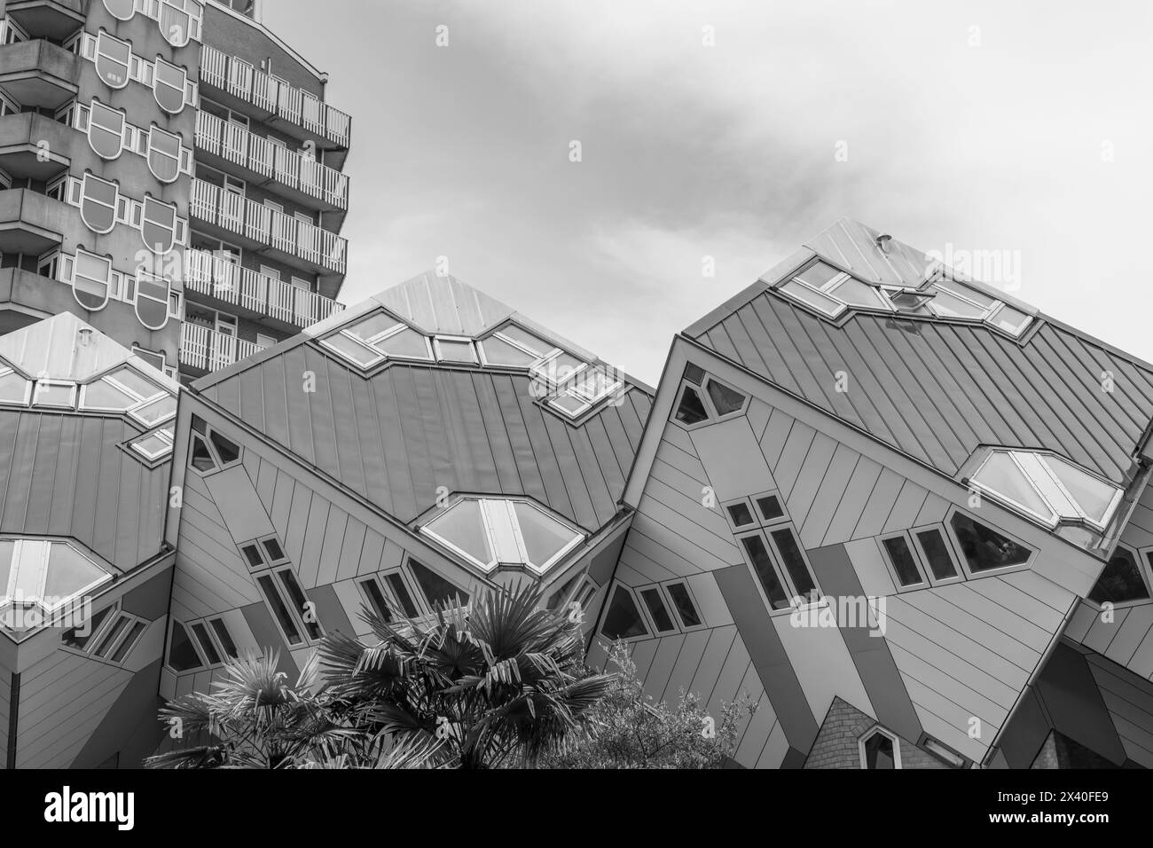
- The Cube Houses (Kubuswoningen): Designed by architect Piet Blom in the 1980s and located near Blaak station, these tilted cubic houses resting on hexagonal pylons represent the concept of "living as an urban roof."
- Markthal: Opened in 2014, this massive horseshoe-shaped indoor market hall combines residential apartments on its exterior arch with a vast food market underneath, featuring a monumental interior digital art mural titled Horn of Plenty.
- De Erasmusbrug: Designed by Ben van Berkel and completed in 1996, this asymmetric cable-stayed bridge spans the Nieuwe Maas, earning the nickname "The Swan" and serving as a vital visual and physical link between the northern and southern halves of the city.
- Depot Boijmans Van Beuningen: Opened in 2021 as the world’s first publicly accessible art storage facility, its reflective, mirrored bowl structure exemplifies the city's ongoing commitment to unconventional public spaces.
| Landmark Name | Architect / Designer | Completion Year | Primary Function |
|---|---|---|---|
| Lijnbaan | Van den Broek & Bakema | 1953 | Pedestrian shopping precinct |
| Cube Houses | Piet Blom | 1984 | Residential housing |
| Erasmusbrug | Ben van Berkel | 1996 | Road and light rail bridge |
| Markthal | MVRDV | 2014 | Market hall and apartments |
| Depot Boijmans Van Beuningen | MVRDV | 2021 | Art storage and museum facility |
Urban Resilience and Climate Adaptation
Because a significant portion of Rotterdam lies below sea level, water management and climate resilience are existential priorities for municipal planning.
The Rotterdam Climate Proof Program
Through initiatives like the Rotterdam Climate Proof strategy, the city has shifted from merely keeping water out to integrating water management into urban design. Rather than relying solely on taller dikes, urban planners utilize multi-functional spaces that can temporarily store excess rainwater during extreme weather events.
Water Squares and Floating Structures
Notable examples of this adaptive approach include:
- Benthemplein Water Square: Designed as a public recreational plaza during dry periods, its sunken concrete basins fill with rainwater during heavy downpours, preventing local flooding in surrounding neighborhoods.
- Floating Pavilion: Located in the Rijnhaven, this modular, floating structure demonstrates the feasibility of climate-resilient floating urban architecture, serving as a venue for meetings and exhibitions.
- Green Roofs: The municipality provides financial incentives for property owners to install green and blue roofs, which insulate buildings, reduce the urban heat island effect, and retain stormwater.
Public Transit and Mobility Infrastructure
Rotterdam possesses a dense, multi-modal public transit network operated primarily by RET (Rotterdamse Elektrische Tram), connecting the city center to surrounding municipalities and regional hubs.
Rail and Rapid Transit
- Metro: The Rotterdam Metro network operates multiple lines connecting the city center to suburbs such as Spijkenisse, Schiedam, Vlaardingen, Capelle aan den IJssel, and The Hague (via the RandstadRail connection).
- Trams and Buses: A comprehensive network of tram lines covers urban thoroughfares, complemented by frequent bus services.
- Waterbus: High-speed passenger ferries connect Rotterdam directly with the surrounding South Holland islands and Dordrecht, providing an integrated maritime transit option for commuters.
Cycling Culture
Like most Dutch cities, Rotterdam maintains extensive, protected cycling infrastructure. While its post-war layout initially favored automobiles more than historic cities like Amsterdam or Delft, ongoing municipal redesigns continue to prioritize separated bike lanes, lower speed limits in residential zones, and bicycle parking hubs at major transit stations like Rotterdam Central Station.
Frequently Asked Questions
Why does Rotterdam look so modern compared to other Dutch cities?
Rotterdam looks modern because the historic city center was almost entirely destroyed by German aerial bombing in May 1940. Rather than reconstructing the damaged medieval buildings, city planners and architects used the destruction as an opportunity to rebuild according to modern functionalist urban planning principles, favoring open space, zoning, and avant-garde architecture.
How does the Port of Rotterdam impact the European economy?
The Port of Rotterdam handles vast quantities of cargo, serving as a primary maritime gateway to the European hinterland. Its integration with rail, road, inland waterways, and pipeline networks allows goods to move efficiently to major industrial centers in Germany, France, and beyond, anchoring regional supply chains.
Is Rotterdam vulnerable to rising sea levels?
Yes, much of the city sits below sea level in a delta environment. However, Rotterdam manages this vulnerability through advanced engineering, including the Maeslantkering storm surge barrier, extensive dikes, pumping infrastructure, and innovative urban water management strategies such as water squares and climate-resilient architecture.
What is the best way to get around Rotterdam?
Public transit—including the metro, trams, and buses operated by RET—provides efficient access to all parts of the city. Additionally, renting a bicycle offers a practical way to navigate the urban layout, thanks to an extensive network of separated bike lanes.
What are the main cultural and architectural attractions in Rotterdam?
Key attractions include the iconic Cube Houses, the architectural Markthal, the Erasmusbrug, the Depot Boijmans Van Beuningen, and maritime heritage sites such as the historic harbor district of Delfshaven, which survived the 1940 bombardment.
Conclusion and Next Actions
Visitors, researchers, and prospective residents should begin by exploring the central district around Rotterdam Central Station and the Lijnbaan to understand the post-war reconstruction layout. For specialized interests, scheduling a harbor tour offers direct insight into global logistics operations at the Port of Rotterdam, while visits to urban resilience sites demonstrate modern climate adaptation practices in practice.
Image Gallery
Select an image to open it in a new tab.


Zara El-Hashem
Sociocultural Dynamics and Academics Writer
