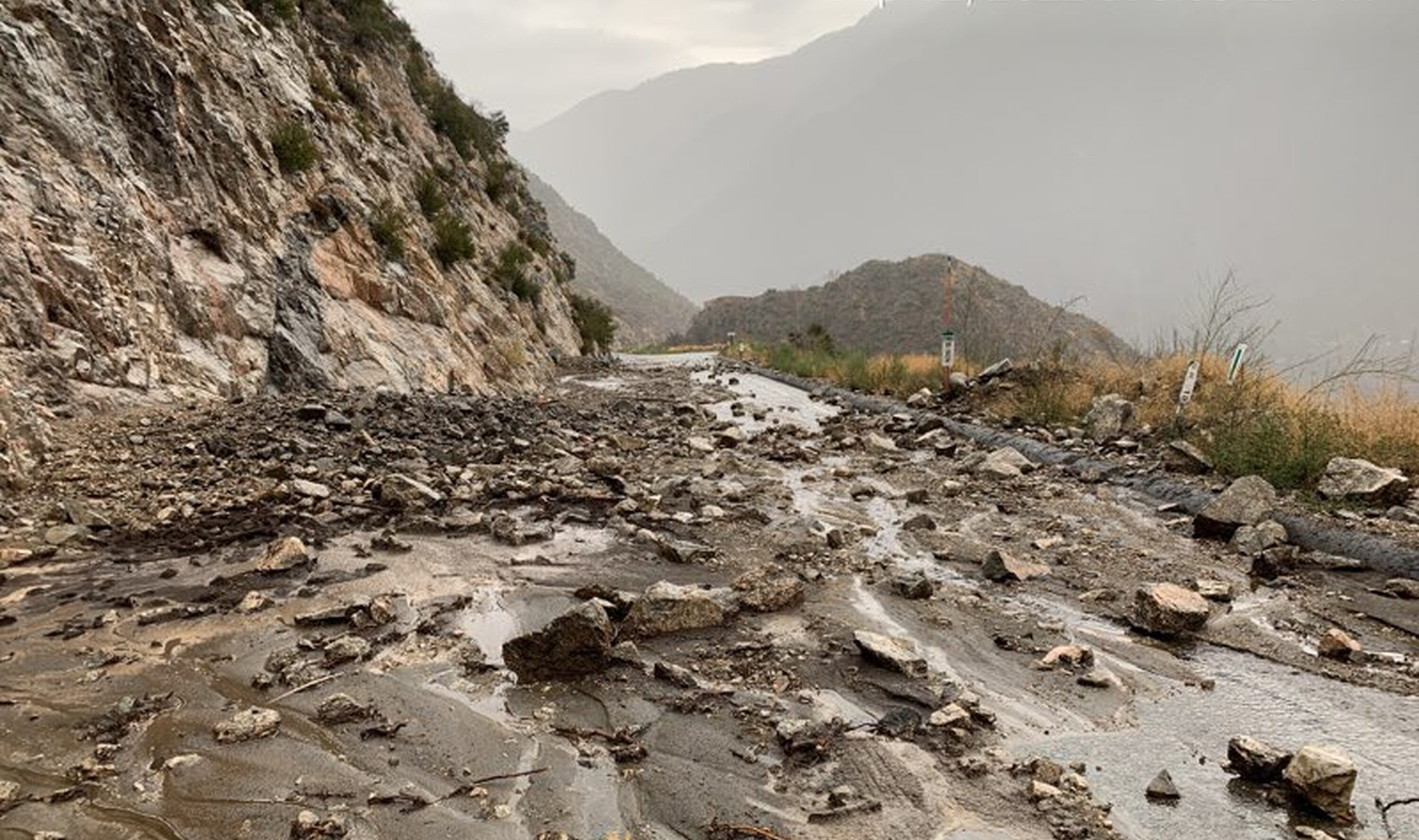
The truth about LA mudslides is that they are rarely just "mud"; most are high-velocity debris flows triggered by a specific "fire-flood cycle." When intense atmospheric river rainfall hits steep, fire-scarred San Gabriel or Santa Monica mountains, the hydrophobic soil fails, sending a mixture of boulders, trees, and sediment into residential alluvial fans below.
While the term "mudslide" is used colloquially by residents and news outlets, geologists and engineers in Southern California distinguish between various types of mass wasting. In Los Angeles, the phenomenon is a predictable, albeit violent, geological process driven by the region's unique combination of young, tectonic mountains and a Mediterranean climate. As of 2026, understanding these nuances is essential for property owners, as standard insurance policies often exclude these events, and the frequency of "whiplash" weather—swinging from extreme drought to record-breaking rainfall—has increased the volatility of the landscape.
Debris Flows vs. Mudslides: A Necessary Distinction
To understand the truth about these events, one must first recognize the mechanics of the "debris flow," which is the primary threat in the Los Angeles basin. While a traditional landslide involves a cohesive mass of earth sliding down a slope, and a mudslide is primarily water-saturated soil, a debris flow behaves like liquid concrete.
Debris flows are remarkably dense, often carrying objects as large as cars or house-sized boulders. They move at speeds exceeding 20 miles per hour, making them impossible to outrun. The "truth" that many residents miss is that these flows do not require a massive amount of total rain; rather, they require a specific rainfall intensity. When rainfall exceeds a certain threshold—often roughly half an inch per hour in burn scars—the surface soil liquifies and begins its descent.
The Anatomy of a Los Angeles Debris Flow
- Initiation: Intense rain falls on steep slopes, often stripped of vegetation by recent wildfires.
- Entrainment: As water rushes down canyons, it picks up loose rocks, sediment, and downed trees, gaining mass and momentum.
- Surging: The flow often moves in pulses or surges, as temporary "dams" of debris form and then burst within narrow canyons.
- Deposition: Once the flow reaches the mouth of a canyon (the alluvial fan), the gradient decreases, and the mass spreads out, burying everything in its path.
The Fire-Flood Cycle: Los Angeles' Greatest Risk
The most significant factor in LA’s mudslide risk is the "fire-flood cycle." In the semi-arid climate of Southern California, wildfires are a natural and frequent occurrence. When a wildfire burns through the chaparral of the San Gabriel or Santa Monica Mountains, it does more than just remove the root systems that hold soil in place.
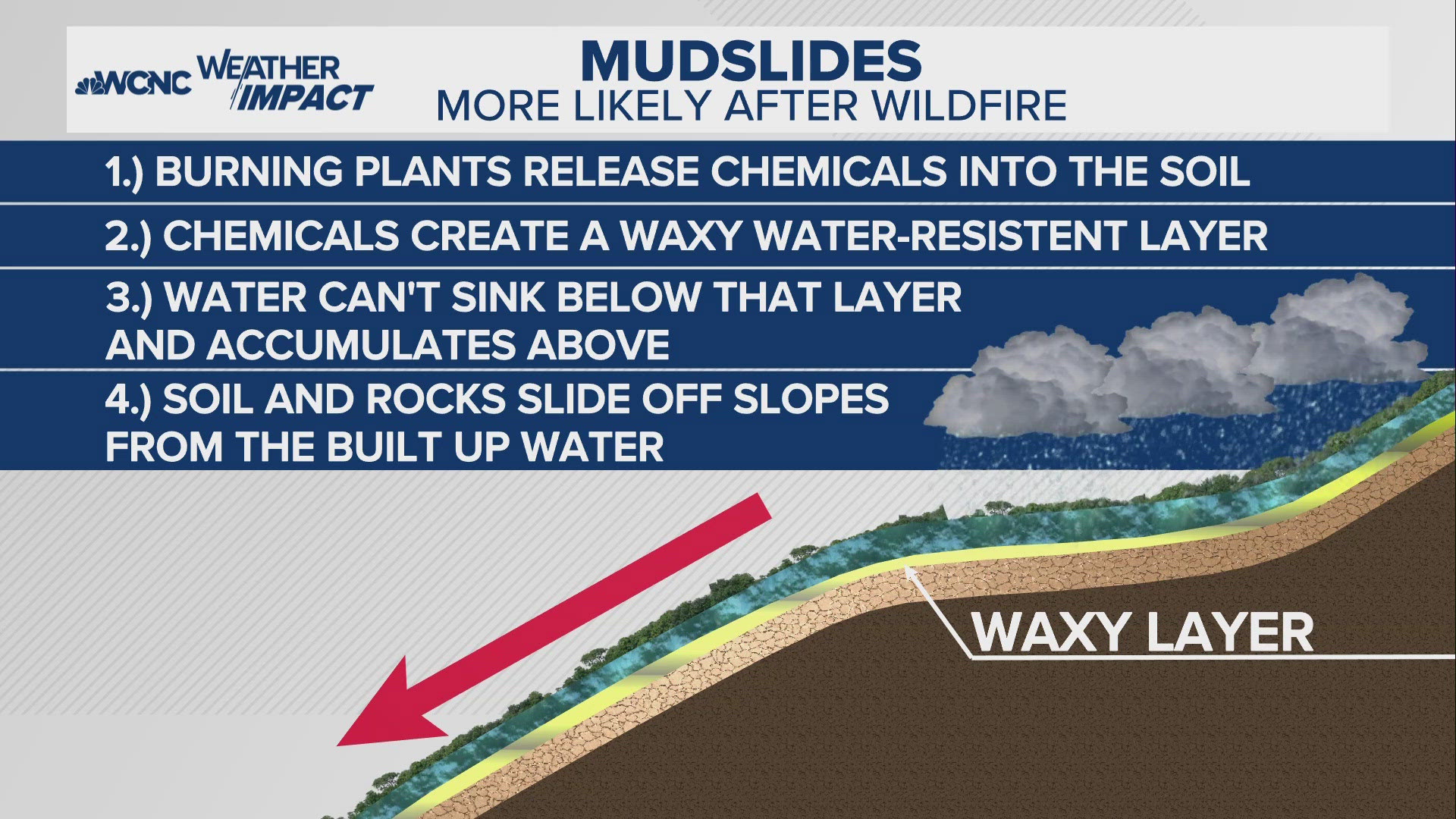
High-heat fires create a hydrophobic (water-repellent) layer in the soil. As organic matter burns, it releases a gas that settles into the cool soil below, creating a waxy, impenetrable coating. When the winter rains arrive, the water cannot soak into the ground. Instead, it sheets off the surface instantly, carrying the top layer of ash and loose soil with it. This creates a "slurry" that initiates the debris flow process.
The danger period for a burn scar typically lasts between three to five years. It takes this long for the hydrophobic layer to break down and for native vegetation to re-establish a root network capable of stabilizing the slopes. In the 2026 landscape, with longer and more intense fire seasons followed by "super-charged" atmospheric rivers, this cycle has become the dominant driver of property damage in the wildland-urban interface.

The Geography of Risk: Why LA is Unique
Los Angeles is geographically predisposed to some of the highest erosion rates in the world. The San Gabriel Mountains are among the fastest-rising mountain ranges on Earth due to tectonic activity along the San Andreas and associated fault systems. Because they are rising so quickly (geologically speaking), they are also crumbling quickly.
The rock in these mountains is often described as "rotten granite"—it is highly fractured and weathered. This means there is a constant supply of loose "detritus" sitting in mountain canyons, waiting for enough water to move it. Much of the flat land where millions of people live in the LA basin is actually composed of alluvial fans—the historical dumping grounds for these very debris flows.
High-Risk Areas in the Los Angeles Basin
- The Foothill Communities: Cities like La Cañada Flintridge, Glendora, and Azusa sit directly at the base of steep canyons in the San Gabriel Mountains.
- The Santa Monica Mountains: Areas like Malibu and Topanga Canyon face risks from both debris flows and traditional deep-seated landslides that can close the Pacific Coast Highway for weeks.
- The Verdugo Mountains: Communities in Burbank and Glendale are susceptible, particularly following fires in the rugged interior of these smaller ranges.
Engineering the Mountains: Debris Basins and Mitigation
The "truth" about LA’s survival in the face of these threats lies in one of the most sophisticated flood control systems in the world. Following the disastrous New Year's Day flood of 1934, which killed dozens in the Crescenta Valley, the Los Angeles County Public Works department began constructing a network of debris basins.
These basins are essentially giant "sinkholes" at the mouths of canyons. They are designed to catch the rocks and trees while allowing the liquid water to pass through into the concrete-lined channel system. There are over 150 of these basins across the county. However, they have limits. During extreme events, a basin can fill to capacity in a single storm. Once full, any subsequent debris flow will "overtop" the basin and spill into the neighborhood below.
| Feature | Mudslide (Mudflow) | Landslide | Debris Flow |
|---|---|---|---|
| Primary Material | Saturated fine-grained soil | Cohesive block of earth/rock | Boulders, trees, ash, and water |
| Speed | Moderate to Fast | Slow to Moderate | Extremely Fast (>20 mph) |
| Trigger | High water table/Saturation | Gravity, rain, or earthquakes | Intense rainfall on burn scars |
| Typical Path | Existing drainage channels | Slope failure (rotational/translational) | Canyons and alluvial fans |
| Primary LA Risk | Localized backyard issues | Coastal bluffs (Malibu/Palos Verdes) | Mountain foothill communities |
Insurance Truths: The Gap Between Risk and Coverage
One of the most painful truths for Los Angeles homeowners is the realization that a standard homeowners insurance policy (HO-3) almost never covers mudslides or debris flows. In the eyes of the insurance industry, these are categorized under "earth movement."
To be protected, homeowners typically need a separate Difference in Conditions (DIC) policy or a specific flood insurance policy through the National Flood Insurance Program (NFIP) that includes "mudflow" coverage. However, the NFIP definition of mudflow is very specific: it must be a "river of liquid and flowing mud" on the surface of normally dry land. If the damage is caused by a "landslide" (the collapse of a hillside), the flood policy may not pay.
As of 2026, the California Department of Insurance has pushed for more transparency, but the burden remains on the homeowner to verify that their coverage specifically mentions "debris flow" or "earth movement." Following the 2018 Montecito debris flow—a landmark event for the region—California law (Insurance Code Section 530) was reinforced to state that if a covered peril (like fire) was the "proximate cause" of an excluded peril (like a debris flow), the damage should be covered. However, this often leads to protracted legal battles between homeowners and insurers.
Practical Mitigation: What Residents Can and Cannot Do
If you live in a high-risk zone, the truth is that individual effort can only do so much against a major geological event. However, specific steps can reduce the risk of smaller-scale damage.
Effective Local Mitigation
- Deflection Walls: Engineered concrete walls can help steer minor flows away from a home’s foundation. These require professional engineering and city permits.
- K-Rails: Temporary concrete barriers (often seen on highways) are frequently deployed by the city or county before a storm to protect streets.
- Drainage Maintenance: Ensuring that yard drains are clear of debris and that water is directed away from slopes is the most effective way to prevent localized "backyard" landslides.
- Sandbags and Plastic Sheeting: While common, these are only effective for minor water diversion. They will not stop a debris flow. Covering a bare slope with plastic sheeting can actually increase the risk of a landslide by trapping water underneath it and increasing pore pressure.
The Limits of Vegetation
While planting deep-rooted native plants is excellent for long-term stability, it is not a "quick fix" for a recent burn scar. Newly planted vegetation often lacks the root depth to hold the soil during a major atmospheric river event. Furthermore, non-native plants like ice plant are actually dangerous on steep slopes; they have shallow roots and hold a tremendous amount of water weight, which can cause the top layer of soil to peel off during a storm.
Survival and Emergency Preparedness
In Los Angeles, the "truth" about mudslide safety is found in the evacuation order. Because debris flows happen so quickly, there is no "warning" other than the rainfall intensity itself. By the time you hear the sound—often described as a freight train or a loud grinding of rocks—it is usually too late to leave.
The USGS Landslide Hazards Program monitors rainfall thresholds across Southern California. When the National Weather Service issues a Flash Flood Watch for a burn scar area, it is a signal that the rainfall intensity has the potential to trigger a flow.
Key Actions for Residents
- Monitor "Ready-Set-Go" Status: Pay attention to Los Angeles County Alert systems. "Set" means you should be packed and ready to leave; "Go" means immediate evacuation.
- Know Your Escape Route: Debris flows follow the path of least resistance—usually streets and driveways. Know multiple ways out of your neighborhood that do not involve crossing a drainage channel.
- Identify High Ground: If caught in a home, the highest floor is the safest place, but being outside or in a vehicle in the path of a flow is often fatal.
- Avoid Low-Lying Areas: During a heavy storm, stay away from the mouths of canyons and the bottom of steep slopes, even if no fire has occurred recently.
FAQ
Is every hill in Los Angeles at risk for a mudslide?
No. Risk is highest on steep slopes (over 25 degrees) with loose, sandy soil or recent fire damage. Deep-seated landslides are more common in areas with specific sedimentary rock layers, such as the Palos Verdes Peninsula or parts of the Santa Monica Mountains. Debris flows, however, are a risk for almost any community located at the base of a mountain canyon.
Does California law require insurers to cover mudslides after a fire?
Under the "Efficient Proximate Cause" doctrine, if a wildfire (a covered peril) was the primary reason the mudslide happened (due to the fire-flood cycle), the insurer is generally required to cover the loss. However, insurers often dispute the cause, and residents are strongly encouraged to have specific "earth movement" or "flood" endorsements to avoid these disputes.
Can I tell if a debris flow is coming?
Often, the first sign is a sudden change in water flow in a nearby creek or street—either a sudden surge or a sudden drop (which could mean a debris dam has formed upstream). You may also hear the sound of boulders knocking together, which sounds like low-frequency thumping or a "freight train" roar.
How long does the danger last after a wildfire?
The highest risk occurs during the first two rainy seasons following a fire. The risk decreases significantly after three years as vegetation returns, though it can take up to five years for a slope to reach its pre-fire stability levels.
Are "atmospheric rivers" making LA mudslides worse?
Yes. While Los Angeles has always had heavy winter rains, climate data in 2026 confirms that atmospheric rivers are becoming more moisture-laden. This increases "hourly rainfall intensity," which is the specific metric that triggers debris flows. We are seeing more "whiplash" events where extreme dry periods are interrupted by violent, concentrated storms.
Next Steps for Residents
If you live near a hillside or a recent burn scar, your first action should be to consult the Los Angeles County Debris Flow Map or your local Office of Emergency Management. Verify your property’s proximity to known alluvial fans or historical flow paths. Secondly, contact your insurance agent to specifically ask about "Difference in Conditions" (DIC) coverage. Finally, create a "Go-Bag" and ensure you are signed up for Alert LA County to receive real-time evacuation orders. Do not wait for a storm to begin before planning your exit; in the steep terrain of Los Angeles, minutes are the difference between safety and catastrophe.
Image Gallery
Select an image to open it in a new tab.


Omar Farooq
EdTech Innovation and Virtual Pedagogy Journalist
