
The eye of a hurricane is calm because sinking air, known as subsidence, suppresses cloud formation and wind within the storm's center. As air spiraling inward reaches the eyewall, centrifugal force prevents it from reaching the absolute center. This creates a low-pressure void where air from the upper atmosphere descends, warms, and clears the skies.
Understanding why the center of the Earth’s most violent atmospheric phenomenon is a sanctuary of tranquility requires an exploration of fluid dynamics, thermodynamics, and the conservation of angular momentum. While the surrounding eyewall hosts winds that can exceed 150 miles per hour, the eye remains a distinct, often circular region of light winds and clear or partly cloudy skies. As of 2026, our meteorological models have reached unprecedented precision in tracking these centers, yet the fundamental physics remains a fascinating study of balance within chaos.
The Anatomy of a Tropical Cyclone
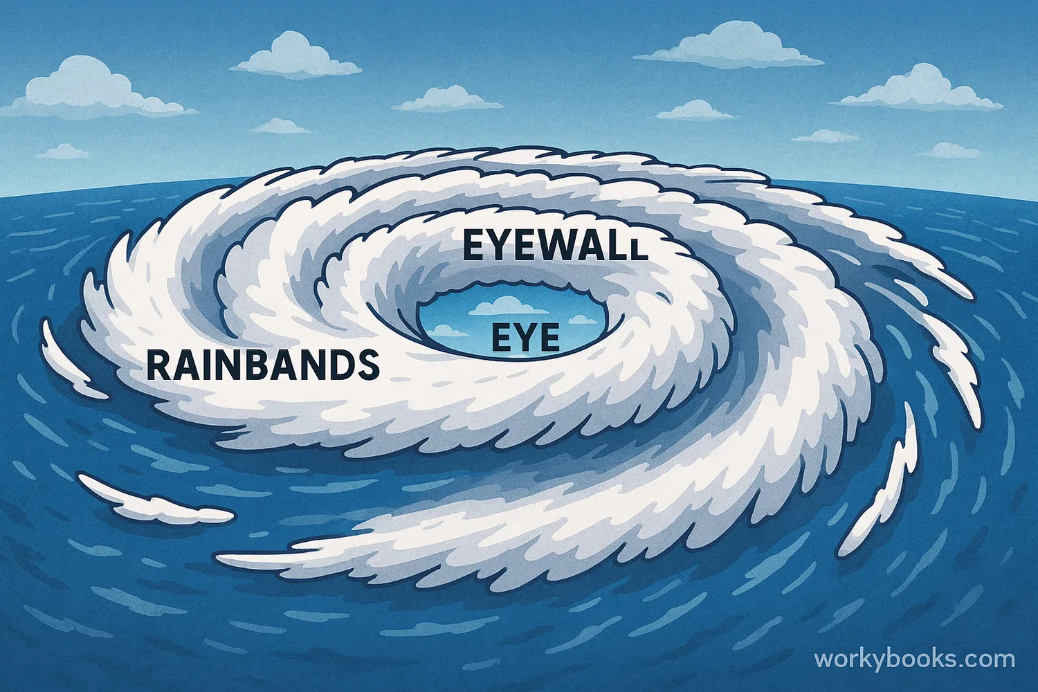
To understand the calm of the eye, one must first visualize the structure of the entire hurricane (or typhoon/cyclone, depending on the region). A hurricane is essentially a massive heat engine that transfers energy from the warm ocean surface to the cold upper atmosphere.
The Rainbands
The outermost layer consists of curved bands of clouds and thunderstorms that spiral inward toward the center. These bands produce heavy bursts of rain and wind, but they are separated by gaps of relatively low activity. They serve as the "intake" system for the storm, pulling in moist, warm air.
The Eyewall
Directly surrounding the eye is the eyewall. This is the most dangerous part of the storm. It is a dense wall of towering thunderstorms where the highest wind speeds are recorded and the heaviest rainfall occurs. The physics of the eyewall is directly responsible for the creation of the calm eye inside it.
The Eye
The eye is the geometric center of the storm, typically ranging from 20 to 40 miles (32 to 64 kilometers) in diameter, though some "pinhole" eyes can be as small as 2 miles, while others expand to over 100 miles. Within this zone, the barometric pressure is at its lowest, but the weather is paradoxically benign.
The Role of Conservation of Angular Momentum
One of the primary reasons the eye exists—and remains calm—is the principle of the conservation of angular momentum. This is the same physical law that causes a figure skater to spin faster when they pull their arms in toward their body.
In a hurricane, parcels of air are drawn toward the center of low pressure. As this air moves inward from the outer edges of the storm, its radius decreases. To conserve angular momentum, the air must speed up. However, there is a limit to how fast and how close to the center this air can travel.
As the wind speed increases, the centrifugal force (the outward-pushing force felt by an object moving in a circle) also increases. Eventually, at a certain radius from the center, the centrifugal force becomes so strong that it balances the inward-pulling pressure gradient force. This point of equilibrium is where the eyewall forms. The air can no longer move closer to the center, so it is forced to rise upward, creating the intense thunderstorms of the eyewall. This leaves the very center—the eye—isolated from the inward-rushing winds.

Subsidence: Why the Sky Clears
If the eyewall prevents horizontal air from entering the center, what fills the space in the eye? The answer lies in the vertical movement of air, specifically a process called subsidence.
In the eyewall, air rises rapidly to the top of the troposphere. Once it reaches the "ceiling" of the storm (the tropopause), most of it flows outward, away from the center. However, a small portion of this air is pushed inward and forced to sink down into the center of the storm.
As this air descends, it undergoes adiabatic heating. In thermodynamics, when air sinks, it is compressed by the increasing atmospheric pressure near the surface. This compression causes the temperature of the air to rise. Because warm air can hold more water vapor than cool air, any existing clouds or moisture in the descending air evaporate.
This sinking, warming air creates a "cap" that prevents the formation of new clouds and dampens wind turbulence. This is why observers in the eye often see blue sky during the day or stars at night, even while surrounded by a 50,000-foot wall of clouds. Detailed technical data on this process can be found through the National Oceanic and Atmospheric Administration (NOAA).
The Pressure Gradient and Wind Speed
A common misconception is that the lowest pressure in a storm must correlate with the highest wind speeds. While the eye has the lowest barometric pressure of the entire hurricane, the pressure gradient—the change in pressure over a specific distance—is actually very flat within the eye itself.
Wind is driven by the difference in pressure between two points. In the eyewall, the pressure drops drastically over a very short distance, creating a steep gradient that generates ferocious winds. Once you cross from the eyewall into the eye, the pressure remains consistently low across the entire diameter of the center. Without a significant pressure difference to "push" the air, the winds drop to near-stagnation.
| Feature | Eye | Eyewall | Outer Rainbands |
|---|---|---|---|
| Wind Speed | Light (< 15 mph) | Maximum (74-150+ mph) | Moderate to High |
| Barometric Pressure | Lowest in the storm | Rapidly falling | Falling steadily |
| Air Motion | Sinking (Subsidence) | Rising (Convection) | Rising/Spiraling |
| Cloud Cover | Clear to Scattered | Solid, Towering Cumulonimbus | Broken layers of clouds |
| Precipitation | Rare/Light mist | Intense/Extreme rainfall | Intermittent heavy rain |
The Stadium Effect
In particularly intense hurricanes (usually Category 3 or higher), meteorologists often observe the "stadium effect." This occurs when the eyewall clouds curve outward with height, creating a shape that resembles a sports stadium.
The physics behind this involves the increase of wind speed with altitude and the centrifugal force pushing the rising air further out as it gains height. For an observer on the ground (or a pilot in a Hurricane Hunter aircraft), the eye appears as a hollowed-out cylinder or bowl. This visual phenomenon is a hallmark of a well-organized, powerful storm system that has reached a high state of thermodynamic efficiency.
Eyewall Replacement Cycles
The calm of the eye is not always permanent throughout the life of a storm. Intense hurricanes often undergo what is known as an Eyewall Replacement Cycle (ERC). This happens when a new ring of thunderstorms forms outside the original eyewall.
The outer ring eventually "chokes off" the moisture and momentum flowing to the inner eyewall, causing the original eye to contract and eventually dissipate. During this transition, the storm may have two concentric eyes. The process usually weakens the storm temporarily but leads to a larger, more stable eye once the outer ring becomes the dominant eyewall. These cycles are critical for forecasters to monitor, as they can lead to sudden changes in the storm's intensity and wind field size.
Scientific Observation of the Eye
To understand the internal mechanics of the eye, scientists rely on both remote sensing and direct "in-situ" measurements. As of 2026, satellite technology like the GOES-R series provides high-resolution infrared and visible imagery every 30 seconds, allowing for real-time monitoring of eye formation.
However, the most accurate data comes from dropsondes. These are GPS-equipped instrument packages dropped from aircraft directly into the eye. As the dropsonde falls, it measures:
- Temperature: Confirming the adiabatic warming of the sinking air.
- Humidity: Measuring the drying effect of subsidence.
- Pressure: Locating the exact center of the storm's circulation.
- Wind Velocity: Confirming the "dead calm" center.
These measurements are vital for computer models that predict the storm's future path and strength. Organizations like the National Hurricane Center (NHC) use this data to issue life-saving warnings.
The Danger of the Calm: A Warning for the Public
The calm of the eye is often a deadly trap for those in the path of a hurricane. When the eye passes over a location, the wind stops abruptly, the rain ceases, and the sun may even come out. This leads many people to believe the storm is over.
In reality, the eye is merely the midpoint. Once the eye passes, the "back side" of the eyewall will hit with equal or greater force, and the winds will come from the opposite direction. This sudden reversal of wind direction can be catastrophic for structures already weakened by the first half of the storm.
Furthermore, the storm surge—the rise in sea level caused by the storm's pressure and wind—is often highest just as the eyewall begins to move back in. Understanding that the calm is a temporary physical phenomenon, not an end to the danger, is a core component of hurricane safety education.
Summary of Physical Requirements for a Calm Eye
The formation and maintenance of a calm eye require specific environmental conditions:
- Low Vertical Wind Shear: If winds at different altitudes are moving in different directions or at different speeds, they will "tilt" the storm and prevent the eye from forming or cause it to collapse.
- Warm Sea Surface Temperatures: A hurricane needs a constant supply of heat (at least 26.5°C or 80°F) to maintain the convection necessary to drive the eyewall and the subsequent subsidence in the eye.
- High Atmospheric Moisture: The system requires humid air to fuel the thunderstorms that create the eyewall structure.
Without these factors, the storm becomes disorganized, and the distinct, calm eye will either fail to form or rapidly fill with clouds.
Frequently Asked Questions
Is the eye of a hurricane completely silent?
While the wind speeds drop significantly, the eye is rarely silent. Depending on the size of the eye, you can often hear the distant "roar" of the surrounding eyewall, which sounds like a continuous freight train or jet engine. Additionally, if you are near the coast, the sound of massive breaking waves caused by the storm surge remains audible.
Can birds get trapped in the eye of a hurricane?
Yes, it is a well-documented phenomenon. Birds often get caught in the eyewall and seek refuge in the calm center. They may fly within the eye for hundreds of miles, unable to push through the violent winds of the eyewall to escape. Radar imagery frequently shows "biological echoes" within the eye, which are actually flocks of trapped birds.
Why do some hurricanes have "ragged" eyes?
A "ragged" eye indicates that the storm is either struggling to organize or is beginning to weaken. This happens when the vertical wind shear is disrupting the symmetry of the storm or when the storm is moving over colder water or land. A perfectly circular, "clear" eye is a sign of a very intense and stable hurricane.
Does every tropical storm have an eye?
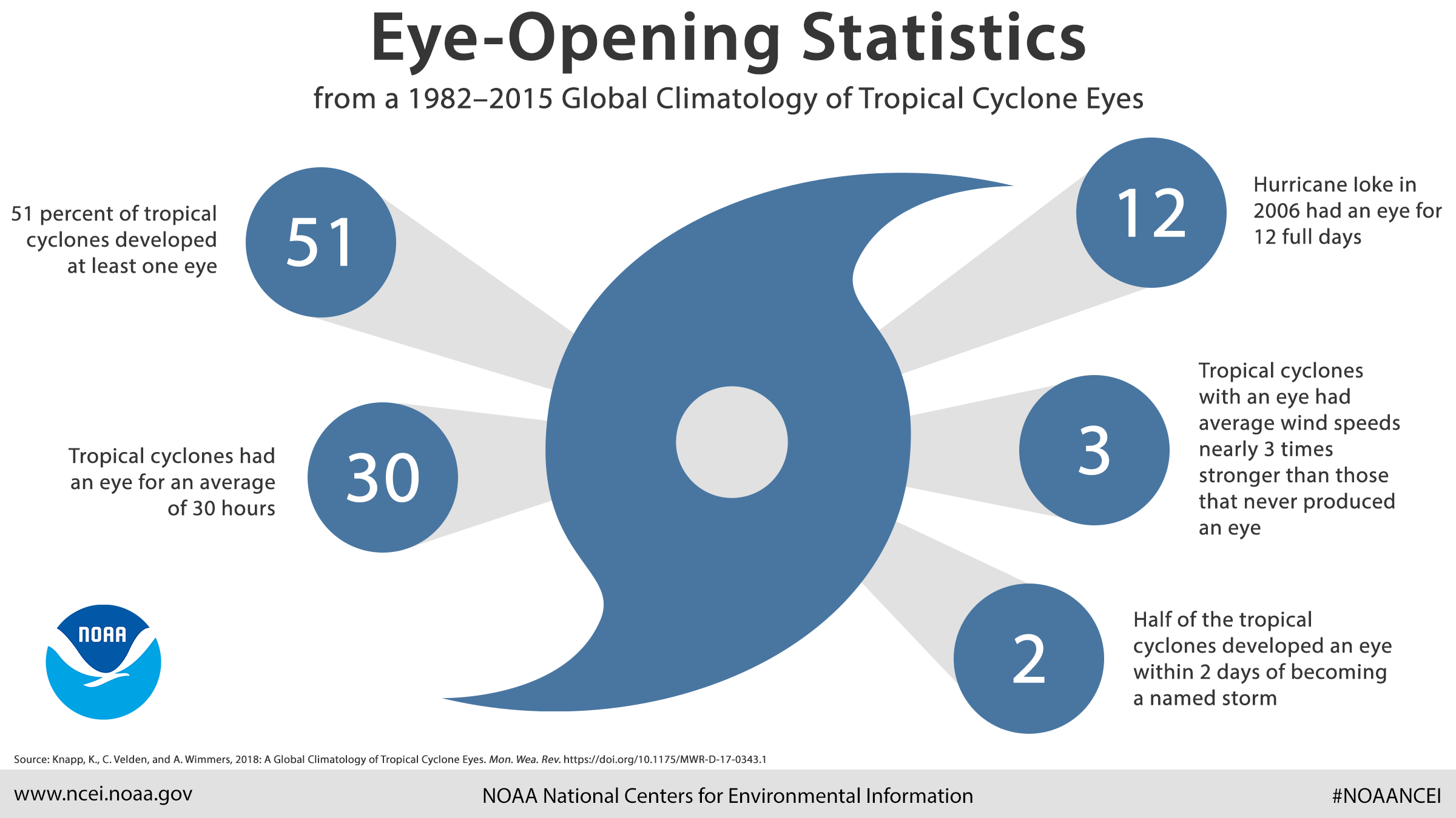
No. An eye typically only forms once a storm reaches hurricane strength (74 mph or 119 km/h). In weaker tropical storms or depressions, the center of circulation is usually covered by a "Central Dense Overcast" (CDO)—a large mass of clouds that obscures any potential eye development.
Is the eye always the warmest part of the storm?
Yes, due to the adiabatic heating of sinking air, the eye is significantly warmer than the surrounding storm. In intense hurricanes, the temperature inside the eye at high altitudes can be 10°C (18°F) or more warmer than the air outside the storm.
Practical Recommendation
If you find yourself in the path of a hurricane, use the calm of the eye only for emergency, short-term actions, such as clearing a blocked drain or checking a critical structural failure. Do not venture far from your shelter. The transition from the calm eye back to the violent eyewall can happen in a matter of seconds, and the winds will return with extreme ferocity from the opposite direction. Always monitor official updates from the National Weather Service or your local meteorological authority during the passage of the eye.
Image Gallery
Select an image to open it in a new tab.

Akira Tanaka
International Academic Trends Correspondent
