
The winter of 2019–2020 was characterized by significant discrepancies between traditional almanac forecasts and actual meteorological events. While many popular sources predicted a "Polar Coaster" with extreme cold and heavy snow, the season ultimately became one of the warmest on record due to a persistently positive Arctic Oscillation and a remarkably strong polar vortex.
Looking back from 2026, the winter period from December 2019 through February 2020 remains a landmark case study for meteorologists. It serves as a reminder of how large-scale atmospheric pressure patterns can override localized seasonal forecasts. During this period, the Northern Hemisphere experienced a season that defied many early "harsh winter" warnings, resulting in one of the most anomalous temperature profiles in modern record-keeping.
The Major Predictions: A Look at the Forecast Landscape
In the autumn of 2019, several major entities released their long-range outlooks. These predictions generally fell into two camps: the traditional, folklore-based methodology of the Almanacs and the data-driven, model-based approach used by the National Oceanic and Atmospheric Administration (NOAA) and private weather firms.
The Farmers’ Almanac and the "Polar Coaster"
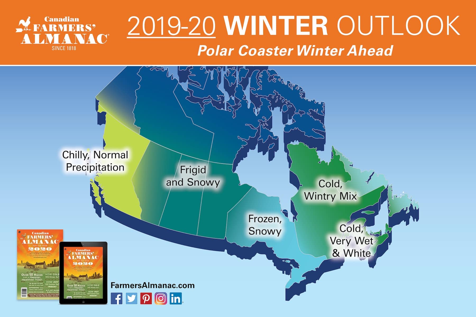
The Farmers’ Almanac (established in 1818) famously branded the 2019–2020 season as a "Polar Coaster." Their prediction emphasized a ride of "ups and downs" that would ultimately land on the side of extreme cold and heavy precipitation. Specifically, they warned of a "suspenseful" season for the eastern half of the United States, suggesting that January would bring frequent storms and plummeting temperatures.
The Old Farmer’s Almanac
Distinct from its competitor, the Old Farmer’s Almanac predicted a "Snowy, Icy, and Icky" winter. Their methodology, which includes solar cycle analysis, suggested that the 2019–2020 season would be one of the coldest in recent memory for many regions. They anticipated a "parade of snowstorms" across the northern tier of the United States and deep into the South, where they predicted rare snow events.
NOAA and the National Weather Service
The National Oceanic and Atmospheric Administration (NOAA) provided a more conservative, model-based outlook. In their October 2019 update, NOAA’s Climate Prediction Center forecasted above-average temperatures for much of the United States, particularly the South and the Northeast. They noted the absence of a strong El Niño or La Niña, categorizing the season as "ENSO-neutral." This lack of a clear signal from the Pacific Ocean made long-range forecasting particularly difficult for the 2019–2020 season.
The Scientific Drivers: Why the Forecasts Diverged
To understand why some 2019–2020 predictions were so far off the mark, we must examine the atmospheric drivers that actually governed the season. The primary culprit for the record warmth was the behavior of the Arctic Oscillation (AO) and the North Atlantic Oscillation (NAO).
The Dominance of the Positive Arctic Oscillation
The Arctic Oscillation refers to the pressure difference between the Arctic and the mid-latitudes. When the AO is in its "positive" phase, a ring of strong winds—the polar vortex—circles the North Pole. This acts as a containment barrier, keeping the coldest air trapped in the Arctic.
During the winter of 2019–2020, the AO remained in a persistently, and at times record-breaking, positive phase. This prevented the "Arctic outbreaks" that the Almanacs had predicted. Instead of plunging south, the cold air remained locked over the polar region, while the jet stream stayed far to the north, allowing mild air from the Pacific and the Gulf of Mexico to flood North America and Europe.
The Strong Polar Vortex
Closely related to the AO, the stratospheric polar vortex was exceptionally strong and stable during this period. In winters with heavy snow and extreme cold (like 2014 or 2021), the polar vortex often "breaks" or stretches, allowing cold air to spill into the U.S. and Europe. In 2019–2020, the vortex never faltered. This stability suppressed the development of the "Polar Coaster" conditions that had been widely anticipated by the public following the previous year’s colder intervals.
The ENSO-Neutral Factor
The El Niño-Southern Oscillation (ENSO) is often the primary tool for seasonal forecasting. In 2019, the Pacific was in a "neutral" state—neither El Niño nor La Niña was present. Without this dominant signal to guide the jet stream, other factors like the AO and the Madden-Julian Oscillation (MJO) took control. The difficulty of predicting these shorter-term oscillations months in advance contributed to the inaccuracy of many long-range forecasts.

Regional Reality: How the Winter Actually Unfolded
The divergence between the 2019–2020 predictions and the actual weather was most stark when viewed through a regional lens. Across the Northern Hemisphere, traditional "winter" weather was largely absent or highly compressed.
| Region | Prediction Summary | Actual Outcome | Deviation from Average |
|---|---|---|---|
| Northeast US | "Polar Coaster," Heavy Snow | Record warmth, minimal snow | +4°F to +6°F |
| Midwest US | "Frigid and Frozen" | Mild temperatures, mixed precip | +3°F to +5°F |
| Southeast US | "Cold and Wet" | Very warm, significantly wet | +2°F to +4°F |
| Western US | "Cooler and Drier" | Near average to slightly warm | +1°F to +2°F |
| Europe | "Severe Winter" (some sources) | Warmest winter on record | +3.4°C (approx) |
| Canada | "Brutal Cold" | Milder than average in the East | +2°F to +4°F |
The "No-Snow" Winter in the Eastern United States
For cities like New York, Philadelphia, and Washington D.C., the winter of 2019–2020 was a major disappointment for snow enthusiasts. New York City’s Central Park recorded less than 5 inches of snow for the entire season, well below the average of approximately 25 inches. Many areas in the mid-Atlantic saw their first-ever winters with almost zero measurable snowfall. This was a direct result of the storm track being pushed too far north and west, leaving the coastal plain in the "warm sector" of nearly every passing low-pressure system.
Europe’s Record-Breaking Warmth
The winter of 2019–2020 was even more extreme in Europe. According to the Copernicus Climate Change Service, it was the warmest winter ever recorded for the continent. In parts of Russia and Northern Europe, temperatures were 6°C (nearly 11°F) above the 1981–2010 average. In Moscow, the absence of snow for much of the winter forced the city to use artificial snow for holiday displays, a stark contrast to the "General Winter" reputation the region holds.
Impacts on Infrastructure and Economy
The failure of the "harsh winter" predictions had significant economic consequences. When organizations plan for a "Polar Coaster," they allocate resources that may go unused if the weather remains mild.
Energy Consumption
Because the 2019–2020 winter was so warm, the demand for heating oil and natural gas plummeted across the Northern Hemisphere. This led to a surplus of energy supplies and lower utility bills for consumers, but it strained the revenue models of energy providers who had hedged against a colder season.
Agriculture and Forestry
The lack of a deep freeze had a complex impact on agriculture. While it reduced heating costs for greenhouses, the lack of "chill hours" was detrimental to certain fruit crops, such as peaches and apples, which require a specific amount of cold time to go dormant and produce healthy blooms in the spring. Furthermore, the mild temperatures allowed pests that are usually killed off by sub-zero temperatures to survive into the 2020 growing season.
Retail and Winter Tourism
The retail sector struggled with a surplus of winter apparel. Boots, heavy coats, and snow shovels remained on the shelves well into February, leading to aggressive discounting. Similarly, ski resorts in the eastern U.S. and low-altitude resorts in the Alps faced significant operational challenges, relying heavily on artificial snow-making, which is energy-intensive and less effective when overnight temperatures remain above freezing.
Lessons Learned in Meteorological Forecasting
The 2019–2020 season served as a turning point for how the public perceives seasonal outlooks. It highlighted the limitations of the "Almanac" style of forecasting, which often relies on historical cycles and secret formulas that do not account for the rapid changes in global climate baseline temperatures.
- The Shift in the "Normal": Meteorologists have had to adjust what constitutes an "average" winter. As global temperatures rise, the baseline for "normal" in 2026 is significantly higher than it was in the mid-20th century.
- Short-term vs. Long-term Signals: The season proved that even with advanced satellite data, the unpredictable nature of the Arctic Oscillation can override more predictable signals like ENSO.
- Communication of Uncertainty: The failure of the "Polar Coaster" prediction led to a shift in how weather agencies communicate. There is now a greater emphasis on "probabilistic" forecasting—showing the likelihood of various outcomes—rather than making definitive "one-size-fits-all" predictions.
Comparison of Methods: Science vs. Tradition
When evaluating the 2019–2020 predictions, it is clear that data-driven models performed better than folklore-based methods, though even the models struggled with the intensity of the AO’s positive phase.
The Farmers’ Almanac and the Old Farmer’s Almanac often use vague terminology like "unsettled" or "crisp," which can be interpreted in various ways. However, their specific calls for a "frozen" and "snowy" East were objectively incorrect. Conversely, NOAA’s map showing a high probability of above-average temperatures for the Southern and Eastern U.S. was largely vindicated, even if the models underestimated the sheer magnitude of the warmth in the Northeast.
Frequently Asked Questions
What was the "Polar Coaster" prediction?
The "Polar Coaster" was a term coined by the Farmers' Almanac to describe the anticipated winter of 2019–2020. It suggested that the season would be defined by extreme fluctuations in temperature and frequent, heavy precipitation, particularly in the eastern United States. In reality, the "ups" (warmth) far outweighed the "downs," and much of the precipitation fell as rain rather than snow.
Why was there so little snow in the winter of 2019–2020?
The lack of snow was primarily due to the jet stream's position. Because the Arctic Oscillation was in a strong positive phase, the jet stream stayed far to the north. This prevented cold, Arctic air from meeting with moisture-rich storms over the populated areas of the East Coast and Europe. Without the "cold" ingredient, storms that would typically produce snow instead produced rain.
Was the winter of 2019–2020 the warmest ever?
For Europe, yes, the winter of 2019–2020 was the warmest on record since data collection began. For the contiguous United States, it was the sixth warmest winter on record at that time. It was particularly notable for being the warmest winter on record for several states in the Northeast and for many individual cities.
Did the Polar Vortex "collapse" that winter?
No. In fact, the opposite happened. The polar vortex was exceptionally strong and stable during the 2019–2020 winter. A "collapse" or "splitting" of the vortex is what causes extreme cold to move south. Because it remained strong and centered over the North Pole, the cold air was effectively "trapped," resulting in mild conditions for the mid-latitudes.
How accurate are the Farmers' Almanacs generally?
The Almanacs claim an accuracy rate of around 80% to 85%, but independent meteorological studies often find their accuracy to be closer to 50%—essentially the same as chance. Their 2019–2020 predictions are often cited by meteorologists as a prominent example of how these traditional methods can fail to account for modern atmospheric dynamics.
Recommendations for Using Seasonal Predictions
When looking at seasonal predictions in the future, it is essential to prioritize sources that utilize ensemble modeling and provide updates as the season approaches. The winter of 2019–2020 demonstrated that a prediction made in August may be completely invalidated by atmospheric shifts occurring in November.
For those planning activities or business operations dependent on winter weather, rely on the NOAA Climate Prediction Center or the European Centre for Medium-Range Weather Forecasts (ECMWF) for the most statistically sound outlooks. Always look for the "probability" of outcomes rather than a single, definitive narrative. Understanding that a "warm" prediction doesn't mean zero snow—just as a "cold" prediction doesn't guarantee a blizzard—is key to accurate planning.
Image Gallery
Select an image to open it in a new tab.


Akira Tanaka
International Academic Trends Correspondent
